|
©The Archaeological Settlements of Turkey - TAY Project
|
|
|
|
|
|
Yarimburgaz Magarasi |
|
|
For site maps and drawings please click on the picture...  |
For photographs please click on the photo... 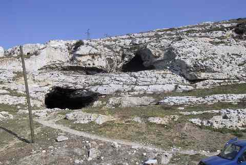 |
|
Type:
|
Cave |
|
Altitude:
|
20 m |
|
Region:
|
Marmara |
|
Province:
|
Istanbul |
|
District:
|
Küçükçekmece |
|
Village:
|
Altinsehir |
|
Investigation Method:
|
Excavation |
|
Period:
|
Early Middle |
|
|
|
 |
|
| Location: This double mouthed cave lies approximately 22 km northwest of the city of Istanbul in the district of Küçük Çekmece; about 1.5 km north of the northern shore of the Küçük Çekmece Lake. It is 1 km north of the shantytown of Altinsehir (now a district of Istanbul); northeast of the road from the village of Samlar; which is north of Altinsehir; to Kayabasi; on the east bank of the Sazlidere (Azatli) River which empties into the Küçük Çekmece Lake. Because the cave has two mouths; the site is also referred to in the plural as the Yarimburgaz Caves. |
| Geography and Environment: The Yarimburgaz Cave; created by the erosive power of a subterranean river on the western flank of a hilly limestone formation facing the Sazlidere River; has two interconnected chambers differing in elevation; size and shape. Each chamber has its own entryway. The caves are between 11-18 m above the Marmara sea-level. The upper section of the cave; oriented roughly northeast-southeast (Upper Cave / Gallery B) appears to be a large hall; approximately 15 by 52 m and presently 10 m high. It is likely that parts of the cave were leveled and that the space was used as a church in Byzantine times. Holes in the cave walls indicate that the cave also supported a tile-paved loft. It is certain that the monasterial structures outside the cave are associated with this occupation phase. To reach the lower chamber (Lower Cave/Gallery A) from the upper cave; it is necessary to descend an incline near the mouth of the cave. What appears to be a gallery develops into tunnel shaped meandering passages with occasional large halls. In contrast to the upper chamber; which quickly comes to an end; the lower chamber continues for approximately 600 m. 240 m beyond the entrance of the lower cave; the passage forks into two. The right branch continues further than the left; funneling to a narrow impassable corridor. The formation of the cave is probably related to the valley running perpendicular to the Sazlidere River. In the Lower Palaeolithic; this wadi may have been an extension of the cave. Bedrock was reached in the Yarimburgaz excavations near the entrance only. Consequently; the original height of the cave chamber could not be determined. The formation of the cave is believed to be very old. It is further assumed that the environmental conditions in the Palaeolithic times were very different than today. Due to its proximity to the Istanbul city center; the Yarimburgaz Caves have attracted the attention of picnickers; treasure hunters and other illegal explorers; speleologists and amateur archaeologists. This increased after Kansu and Kökten began excavation. Perhaps the foremost reason for this interest is the fact that the caves were used as a church in their final phases. The caves have also been used by movie and television makers as a film setting. The Ministry of Culture has neglected the caves by allowing a grader into the cave to level the ground for a mushroom farm. In order to stop these destructive activities performed by various people; organizations and especially by the treasure hunters; the caves have been closed off by iron bars since the Arsebük excavations. This has decreased the amount of damage. |
| History: |
| Research and Excavation: The site first gained academic importance as a geological and speleological interest in the mid-nineteenth century. The prehistorical importance of the site was recognized by Sevket Aziz Kansu of the Ankara University DTCF Department of Archaeology; who dug a sounding which cannot be called a proper excavation; in 1959. Excavations: The first excavations carried out at the site; under the leadership of Sevket Aziz Kansu and Kiliç Kökten; in the entrance of the lower cave in 1963 [Kökten 1963b:277-278] were later continued more systematically under the direction of Kansu; Kökten and N. Dolunay in 1964 and 1965. They divided the cave into a grid of squares (referred to by Kansu as "parcels")[Kansu 1966:491-492]. The damage the site suffered in the twenty years between 1966 and 1986 instigated a second round of excavations which were carried out in 1986 for the Istanbul Archaeological Museum by Mehmet Özdogan of the University of Istanbul; Faculty of Letters; Prehistory Section; and a team of excavators from this university. Following this salvage excavation; which established that the oldest occupation in the cave dates to the Lower Palaeolithic; a third phase of excavations was undertaken in order to further understand Turkey's Pleistocene Archaeology. They were conducted jointly by another member of the University of Istanbul (Faculty of Letters; Prehistory Section); Güven Arsebük and by F. Clark Howell of the University of California at Berkeley (Anthropology Department) between the years 1988 and 1990. The stratigraphy as determined by the excavations: In the first set of excavations carried out in Gallery A of the lower cave; beneath a 40 cm top layer consisting of dung; and a second 60 cm level with Byzantine sherds; a third yellowish silty and sandy layer with pebble tools and debitage was unearthed. According to Kökten; this stratum dates most probably to the Middle Palaeolithic. Bedrock was reached 370 cm below the surface; even though later excavations have questioned this. Kansu and Kökten report that teeth and bones of Ursus spelaus; cave bear were found in association with Moustérien coarsely-made points in this third stratum. In the excavations in the upper cave; referred to as "Gallery B"; the first stratum; a layer of dung 30 cm deep was followed by a second 45 cm layer of Byzantine material culture. According to the excavation directors; the stratum beneath this is a 200 cm thick Chalcolithic deposit. Due to the restricted extent of excavation in this upper gallery; it has not yet been determined whether the Chalcolithic material originates from a large pit. In the southern part of the trench; the Palaeolithic layer of yellowish silty sand starts at 480 cm below the surface and continues down to the bedrock. Kansu has not specified which part of the Palaeolithic this layer belongs to. In the north of the trench; bedrock appeared at a deeper level. It is not surprising that the second phase of excavations in 1986 were more detailed and systematic. A very different stratigraphy emerged in this excavation; which was directed by Özdogan. Excavations were now concurrently conducted in the upper and lower caves; and all the cultural phases present in the Yarimburgaz caves came to light. Upper cave strata 15-12 and lower cave strata 12-3 were dated to the Lower Palaeolithic. Finds of pebble tools suggested that these Yarimburgaz strata belonged to the beginning of the Middle Pleistocene and earlier. This was proven wrong in the third phase of excavations led by Arsebük. Small hearths and other evidence for habitation are especially interesting. The second phase of excavations dated the Yarimburgaz caves at one million B.P. Further research; however; has made it clear that they are slightly more recent. The second lowest deposit; dated to the Middle Pleistocene by Özdogan include strata 11-8. Habitation in this period is believed to have been intermittent. Immediately above this deposi t; Özdogan identified Upper Palaeolithic and Epipalaeolithic deposits in the upper caves in the 7th and 6th strata. The 5th stratum in the upper cave represents the Neolithic era. Following the Neolithic; again in the upper cave; strata 4-2; belonged to the Chalcolithic. Finds from this period were set into a natural depression in the interior of the upper cave. The first stratum is the only one that is the same in both caves. Stratum 1 included a dressed-stone wall built where the two caves meet. This stone structure is probably the apse of a church dating to the earliest Christian times. For several reasons; the third phase of excavations in the Yarimburgaz caves were carried out in the lower cave. The later Byzantine layers in this part had eroded due to water action; leaving not only a hard protective shell above the Middle Pleistocene layers but also relatively little Byzantine material culture. These excavations led by Arsebük aimed primarily at shedding light on the Pleistocene Epoch. Geomorphological and palaeo-ecological studies have accompanied the archaeological excavations in and around the cave area. The results have not altered the stratigraphic sequence of the second phase excavations significantly. Arsebük has categorized the Pleistocene deposits into four different geological categories. The first two of these are conglomerate layers composed of quartz rubble. The surfaces of these layers have cement-like appearances. Beneath this lies a silty; dark-reddish brown layer. This third stratum varies from the first two because it comprises the genuine Pleistocene deposits and is rich in material culture. The last set of excavations has led to the conclusion that the Yarimburgaz occupation; dating to the Middle Pleistocene; is the oldest known habitation in Turkey today. Next in importance only to the Karain cave; the Yarimburgaz Caves have a great potential for stratigraphic research. This further emphasizes the importance of the cave and its multi-disciplinary study. It was mentioned in the registered archaeological sites list prepared by Ministry of Culture and Tourism. |
| Stratigraphy: The Chalcolithic levels exist; like the Neolithic levels; only in the Upper Cave. The recovery of the Chalcolithic levels; below the Byzantine deposit; during the excavations conducted by Kansu; Kökten and Dolunay on behalf of Türk Tarih Kurumu (Turkish History Foundation) has increased the importance of the cave and has been the basis for the 1986 excavations. The Levels 2-4 in the gallery named Upper Cave; are dated to the Chalcolithic Age by Özdogan. Of these; the 2nd Level is observed to have two phases and the 3rd Level is defined as a transitional deposit. The 5-10 cm thick deposit withholds numerous mussel shells; and yet is poor in pottery finds. In the 4th Level two layers are recognized. The existence of a hut from this distinguishable level; with a deposit containing burnt timber and mudbrick remains; is possible. On the other hand; the plan of this structure is impossible to determine as a result of both Kansu's excavation and later destruction. |
| Small Finds: Pottery: 2nd Level: Hand-made; mica and grit-tempered; fine pasted wares have glossy black; dark or light brown; sparsely mottled reddish brown; light buff; and light gray surface colors; they are paint-slipped. Walls are usually thin and coarse examples are very rare. Slightly carinated open vessels or spherical bowls and deep bowls are the frequent forms. There are also carinated jars with high neck and cups with strap-handles. Frequent decoration techniques are incision; scratching; and pointille; whereas shallow channelling; grooving; deep incision; and knob decoration are rarely used. The decoration lies between the rim and the belly all around the vessel in most examples. There are geometric motifs like "Z" shaped lines; "V" shaped triangles; parallel lines; and refracted lines. Vessels are generally well-fired [Özdogan 1990:379]. 3rd Level: Pottery of this level is not explained in the text; but the photographs show that shallow channelling and curving lines are used as decoration [Özdogan 1990]. 4th Level: The carefully hand-made ware has higher sand and mica temper compared to those from the 2nd Level. The prefered surface colors are reddish-brown and matt grayish black; and the others are matt black; orange red; and buff. Almost all vessels are burnished; red and buff beingrather glossy. Significant forms are open S-profile bowls; open ovoid vessels; spherical jars with low or high necks. Decoration lies on the neck on the samples with high necks and on the shoulder on the sherds with low neck. Meander; refracted line; zigzag; and stair patterns are positioned in the triangles in horizontal bands on the neck. Özdogan states that this distribution of decoration on the surface is significant to Yarımburgaz. Simpler decorations constituted by refracted lines and dot-impressions are used as well. Ground Stone: Grinding stones and burnished flat axes imply that the cave was a dwelling rather than a sacred place. |
| Remains: |
| Interpretation and Dating: Özdogan has tried to involve the well-stratified finds of the site in the cultural sequence of Marmara Region in his preliminary reports. Stating that the 4th Level pottery is unfamiliar to the Fikirtepe-Pendik culture of the region; Özdogan proposes that this material may be exposing a later phase in the continuum of this culture [Özdogan 1990:382] and assumes that some unfamiliar features may hint interrelations with Central Europe and Thessaly. The 2nd Level finds are completely different from the cultures of Western Anatolia and Marmara Region. New research and excavations in Marmara Region will make clear if these remains are of a local culture or not. |