|
©The Archaeological Settlements of Turkey - TAY Project
|
|
|
|
|
|
Baglama |
|
|
For site maps and drawings please click on the picture...  |
For photographs please click on the photo... 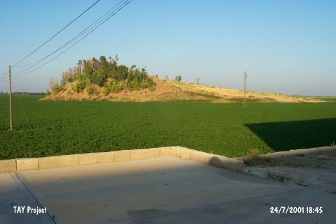 |
|
Type:
|
Mound |
|
Altitude:
|
100 m |
|
Region:
|
Mediterranean |
|
Province:
|
Hatay |
|
District:
|
Merkez |
|
Village:
|
Marasbogazi |
|
Investigation Method:
|
Survey |
|
Period:
|
EBA I |
|
|
|
 |
|
| It lies on a plain shaped by the Lake Amuq; immediate east of Antakya-Kirikhan motorway; in the vicinity of Baglama Village; northwest of the Lake Amuq; northeast of Hatay Province. It is locally known as Ain-al-Samak. It is reported that in 1935 when the survey was conducted; it was a high and big mound. Two sides are steep whereas the others have a softer inclination. R. Braidwood who discovered the mound and suggested that the site had been inhabited during the Jamdat Nasr Period (EBA I); the second and first millennia BC claimed that the road running to the Bailan Alley was under the control of this settlement. It takes place in the registered archaeological sites list prepared by Ministry of Culture and Tourism. |
| Location: |
| Geography and Environment: |
| History: |
| Research and Excavation: |
| Stratigraphy: |
| Small Finds: |
| Remains: |
| Interpretation and Dating: |