|
©The Archaeological Settlements of Turkey - TAY Project
|
|
|
|
|
|
Velican |
|
|
For site maps and drawings please click on the picture...  |
For photographs please click on the photo... 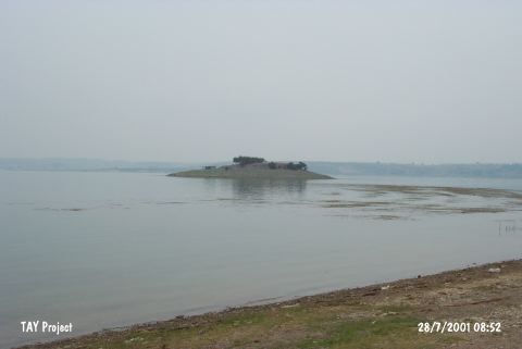 |
|
Type:
|
Mound |
|
Altitude:
|
110 m |
|
Region:
|
Mediterranean |
|
Province:
|
Adana |
|
District:
|
Seyhan |
|
Village:
|
Karsli |
|
Investigation Method:
|
Survey |
|
Period:
|
|
|
|
|
 |
|
| It lies on the borders of the dam lake although it used to be on the western bank of the Seyhan River before the construction of the dam. It is inVelican Quarter of Karsli Village; 12 km north of Adana Province. Together with the bedrock beneath which is 10 m high; it measures 15-17 m in height. Materials collected and preserved in the Museum of Adana expose that the site had been inhabited from the Chalcolithic Age to the Iron Age. Samples of the red and black burnished ware are dated to the EBA. J. Mellaart illustrates it in the distribution map of the Konya metalic ware. |
| Location: This site lies in Velican Quarter of Karsli Village; 12 km south of the city of Adana. |
| Geography and Environment: The site was lying on the western shore of the Seyhan River; at the beginning of the narrow valley created by this river before the construction of the dam. It is nearby the dam reservoir today. With the 10 m thick rock outcrop it lies on; the total height of the mound is 15-17 m. Although claimed to be the earliest settlement in the Province of Adana doubts remain. |
| History: |
| Research and Excavation: |
| Stratigraphy: |
| Small Finds: |
| Remains: |
| Interpretation and Dating: |