|
©The Archaeological Settlements of Turkey - TAY Project
|
|
|
|
|
|
Tepesidelik |
|
|
For site maps and drawings please click on the picture...  |
For photographs please click on the photo... 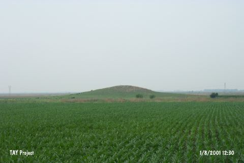 |
|
Type:
|
Mound |
|
Altitude:
|
80 m |
|
Region:
|
Mediterranean |
|
Province:
|
Adana |
|
District:
|
Ceyhan |
|
Village:
|
Merkez |
|
Investigation Method:
|
Survey |
|
Period:
|
|
|
|
|
 |
|
| It lies south-southeast of Yalak Village; south of the road to the village; about 11 km northeast of Ceyhan District of Adana Province. It is a medium size mound. It is long and oval. It measures 15 m in height. Traces of heavy ploughing can be observed on the surface. Limited number of Roman Period sherds were recovered. the main occupation was suggested to be during the prehistoric period. The surface collection during the Cilicia survey conducted under M.V. Seton-Williams in 1951 yielded plenty of EBA and Hittite pottery. Samples of the red and black burnished ware are dated to the EBA. Also; samples of the metallic ware were collected during the Mellaart's survey. It was researche dwithin the scope of the "Adana (Ceyhan) and Kayseri (Develi) Surveys" performed by S. Girginer et al. in 2005. It is a 12 m high mound. The agricultural activities outside the northern slope of the mound destructs the mound. It is in a location near the area where Ceyhan river changes its course. There are pottery belonging to straw tempered Chalcolithic Age group; as well as pottery belonging to EBA; and 2nd Millenium BC; Roman-Byzantien Periods; and obsidian and silex production waste; and blades [Girginer 2007:176-177]. |
| Location: |
| Geography and Environment: |
| History: |
| Research and Excavation: |
| Stratigraphy: |
| Small Finds: |
| Remains: |
| Interpretation and Dating: |