|
©The Archaeological Settlements of Turkey - TAY Project
|
|
|
|
|
|
Tell el Cüdeyde |
|
|
For site maps and drawings please click on the picture... 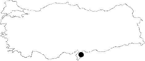 |
For photographs please click on the photo... 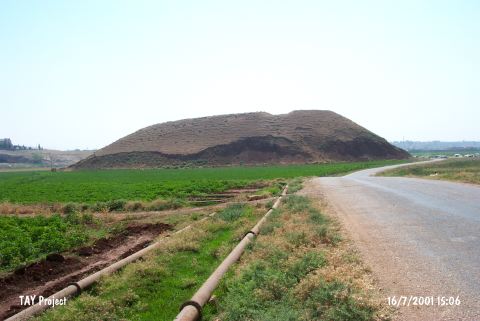 |
|
Type:
|
Mound |
|
Altitude:
|
220 m |
|
Region:
|
Mediterranean |
|
Province:
|
Hatay |
|
District:
|
Reyhanli |
|
Village:
|
Merkez |
|
Investigation Method:
|
Excavation |
|
Period:
|
EBA I EBA II EBA III |
|
|
|
 |
|
| Location: The site lies southeast of Antakya; 1.8-1.9 km east-southeast of Reyhanli District. |
| Geography and Environment: The site is one of the biggest mounds in Amuq Plain; on which; more than 200 settlements; dating to various periods; are located due to the most recent survey. The site; surrounded by fertile lands irrigated by the branches of Afrin Stream; is convenient for settling. The mound measures 370 m in East-West axis; 250 m n North-South axis; and 31 m high above the level of the plain. A desiccated lake is located at the north. A creek; named Kizil Ark or Nahr el Cüdeyde; flows east of the mound. This creek was most probably used as a water source by the inhabitants. The site is observed to be severely damaged like the other mounds in Amuq Plain. A mudbrick wall; probably a fortification; has been revealed by a bulldozer; and is about to vanish. Amuq Plain (named incorrectly as Amuq Plain in the archaeological publications) lies east of Amanos Ranges; and covers an approximate area of 55x40 km. The plain reaches the Mediterranean on the southwestern extension. The ardent lands of Northern Syria; like deserts with low hills; lie east of Amuq Plain. Orontes and its branches not only irrigate the plain; but create fertile lands by the alluvium it accumulates. The site is more convenient in climate for settling; compared to Northern Syria. |
| History: |
| Research and Excavation: The site was discovered in 1933 during the surface survey conducted by R.J. Braidwood of the University of Chicago Oriental Institute. Excavations on the mound were begun in 1935 under Braidwood's direction. The oldest layers of the mound were reached (neolithic); was opened in the west-northwestern slope of the mound. The EBA levels were reached at trenches JK and TT20 during the excavation conducted by Braidwood covering a very restricted area. For example; Phase H of the Amuq was dug only in an area of 116 squaremeters. The extreme damage done between 1935 and 1995 has made it necessary for the Institute to initiate a second campaign of excavations. Research conducted by the Oriental Institute; Chicago was resumed in 1995 under the direction of A. Yener. In the first season; a regional surface survey was conducted and a salvage excavation was begun at Tell el Judaidah. T. Wilkinson has since been continuing archaeological and geomorphological research in the area [Yener et al. 1996a:49]. The second campaign was more like a sounding for recording the remains in the destructed area. It takes place in the registered archaeological sites list prepared by Ministry of Culture and Tourism. |
| Stratigraphy: EBA levels of Cüdeyde are presented in accordance with the cultural phases of the Amuq Plain; Trench JK Trench TT 20 EBA IIIa/Amuq I building level 6 - EBA II /Amuq H building levels 7-11 building level XIV/4 EBA I /Amuq G building levels 12-20 building levels XIV/1-3 and XV |
| Small Finds: Architecture (ascending order): Amuq Phase G: The presence of mudbrick buildings on stone foundations is evident by examples of public architecture. The structure of the rooms is quadrangular. They were built in various dimensions regardless of their function. The restriction of the excavated area doesn't allow us to state anything about the interrelations of the buildings as well as the planning of the village. The building level 2 yielded a circular structure built of roughly rounded loam lumps of mudbrick and employed as a pen [Braidwood-Braidwood 1960:260; fig.196]. It is observed that the garbage pits severely damaged the lower building levels. Amuq Phase H: The building levels 10-7 yielded a small area; but structures consisting of a few rooms. At least two rooms and an entrance between them are observed. There is a low silo in the western room of the structure [Braidwood-Braidwood 1960:345; fig.266]. Single and double kilns are the amazing finds of this phase. Cult hearths were uncovered at this level dated to EBA II. The central part and side ends of these horseshoe-like movable hearths; uncovered at Tell Dahab and Tell Tayinat aside Cüdeyde; are depicted as human faces. The details of the face were incised. Even tough they continue through the phase I; these andirons are rather specific to the phase H in the plain. Amuq Phase I: It is the least known phase in the architectural form. No remains providing a plan were uncovered. The movable hearths identified as cult hearths continue in this phase; too. It is considered as a part of the architecture of the Southeastern Anatolia region given its general characteristics of mudbrick fragments and remains of compressed clay floor. Ceramics (ascending order): Amuq Phase G: It is represented by the finds of trench TT20. Among the pottery collected and analyzed; simple plain ware is the most popular one. A specific type of this ware is plates [Braidwood-Braidwood 1960:fig.203/1; 3]. Short-necked; flat or round bottomed; carinated bowls and goblets are found. Also found are sherds of orange-colored ware. Amuq Phase H: The specific pottery industry is the Karaz ware of Eastern Anatolia identified as red-black burnished ware. The glossy orange-coloured ware; recovered from all EBA levels; continue at this phase. 21-26 percent of the whole pottery group is simple plain ware while a percentage of 6 are represented by reserved slip decorated ware. They are largely incision and impressed decorated ware; discord brush decorated ware; kitchen ware and metallic ware. As metallic ware; a sample of Syrian bottle was found [Braidwood-Braidwood 1960:fig.288]. Amuq Phase I: It is represented by an area of 76 squaremeters only at Tell el Cüdeyde. The red-black burnished ware still continues in large quantities as well as the orange colored ware. Simple plain ware is very popular with a percentage of 41-46 %. Reserved slip ware and basic painted ware are represented in small quantities. Clay: Other than simple heads of spindle whorls made of sherds; heads of spindle whorls produced by baking were found. Miniature cosmetics cups are very coarse. Plenty of animal figurines recovered provide an evidence for intense animal husbandry during phase G [Braidwood-Braidwood 1960:fig.237]. Phase H yields cylindrical seals together with animal figurines. Chipped Stone: The industry of phase G is like a continuation of the chipping techniques of the Neolithic Age. Traces of industry F are also observable. Other phases present a chipping stone industry specific to the region. Ground Stone: Phase G yielded elaborate productions of small stone vessels; flat stone axes grounded in each size; batons or mace heads. Plenty of stone beads recovered indicate the ornament traditions of the community occupied the site during EBA I. Raw materials like calcedony; carnelian; agate; marble; limestone; serpentine and dolomite were employed. Aside stamping seals; the first cylindrical seal type of Jamdat Nasr is introduced at this phase. The geometrical and stylized animal patterns of stamping seals of the Chalcolithic Age continue at phase G. The cylindirical seals are carved with plant patterns as well as geometrical patterns. Bone/Antler: Phase G yielded an awl in bone; pin and a tube-like object carved from bones of a lion's leg. Metal: The outstanding samples of tool; weapon and statues which provide the best information about the mining technology of the region were recovered from Tell el Cüdeyde during the Amuq excavations. Phase G yielded plenty of awls and pins [Braidwood-Braidwood 1960:296; fig.239]. An amazing find is a twisted lead ring. The most beautiful and unique finds of this phase are six human idols recovered wrapped into a cloth. This hoard consisting of both male and female idols is an evidence of the extent the miners of this period became the masters particularly in the technique of wax casting; apart from its significance of religious items in the society of EBA I in Anatolia as well as Jamdat Nasr in Mesopotamia. The male figures are naked with spears and mace heads in their hands. They have a head-dress like a helmet; and a thick belt on their belly [Braidwood-Braidwood 1960:fig.240-242]. On the other hand; the female figures are in a praying position; naked again. The small cap on their heads covers the tress of their hair. The idol introduced as idol F was worked very naturally. The woman holds her big breasts with her hands. The copper finds of phase H like winged spear head; willow leaf-like spearhead; except the winged axe; bear all the characteristics of Near East [Braidwood-Braidwood 1960:fig.253]. However; this winged axe is a very early sample of its type. It can be a leakage from the upper levels (e.g. phase J). It is a product of MBA. Phase I did not yield any worth metallic find. |
| Remains: |
| Interpretation and Dating: Tell el Cüdeyde played a major role in the cultural phases identified in the Amuq Plain from the Neolithic Age onwards. The stratification of Cüdeyde contributed; even; to the evaluation of surface finds of many mounds discovered by Braidwood in the Amuq Plain. The phase G is contemporary with Jamdat Nasr period of Mesopotamia; phase H with Ur Dynasty Period I-III and phase I with Akkads Period. There is a tendency to associate the phase G with EBA I of Anatolia; phase H with EBA II and phase I with EBA IIIa. The EBA IIIb and its contemporary period; phase J of the Amique Plain were not identified. Phase G is full of evidence proving the relationship between Cilicia and Southern Mesopotamia. It is very difficult to obtain a settlement plan of Tell el Cüdeyde with the unclear architectural remains uncovered in the excavated areas. It seems that the economy was dependent on the agriculture. The Amuq Plain is; in a way; an exit to the Mediterranean for Mesopotamian cultures. It is connected to Southeastern Anatolia through the Islahiye-Altintop-Sakçagözü plains; to Southwestern Anatolia and Central Anatolia through the Çukurova Plain. The Asi River and the Lake Amuq; desiccated at present to obtain more arable fields; offered better settlement conditions. The plain bearing the characteristics of garden agriculture by means of the streams and brooks coming from the near mountains has a very fertile land for agriculture. Therefore; it attracted the people looking for places to be settled during the prehistoric ages. Among the EBA finds of Cüdeyde; no extraordinary find was seen; except the copper idols of phase G. This may result from the fact that the excavations aiming to identify earlier levels were soundings rather than excavations. Particularly the copper figurines are outcome of a high-tech production. Until the finds of Arslantepe VI A were recovered; those finds were not believed to come from that phase of the Amuq Plain. It is significant to re-conduct the excavations at Tell el Cüdeyde and uncover the lower levels in larger areas to illuminate the archaeology of the region. |