|
©The Archaeological Settlements of Turkey - TAY Project
|
|
|
|
|
|
Tell el Cüdeyde |
|
|
For site maps and drawings please click on the picture... 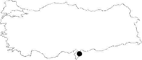 |
For photographs please click on the photo... 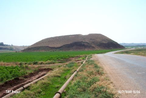 |
|
Type:
|
Mound |
|
Altitude:
|
220 m |
|
Region:
|
Mediterranean |
|
Province:
|
Hatay |
|
District:
|
Reyhanli |
|
Village:
|
Merkez |
|
Investigation Method:
|
Excavation |
|
Period:
|
|
|
|
|
 |
|
| Location: The site lies southeast of Antakya; 1.8-1.9 km east-southeast of Reyhanli District. |
| Geography and Environment: The site is one of the biggest mounds in Amuq Plain; on which; more than 200 settlements; dating to various periods; are located due to the most recent survey. The site; surrounded by fertile lands irrigated by the branches of Afrin Stream; is convenient for settling. The mound measures 370 m in East-West axis; 250 m n North-South axis; and 31 m high above the level of the plain. A desiccated lake is located at the north. A creek; named Kizil Ark or Nahr el Cüdeyde; flows east of the mound. This creek was most probably used as a water source by the inhabitants. The site is observed to be severely damaged like the other mounds in Amuq Plain. A mudbrick wall; probably a fortification; has been revealed by a bulldozer; and is about to vanish. Amuq Plain (named incorrectly as Amuq Plain in the archaeological publications) lies east of Amanos Ranges; and covers an approximate area of 55x40 km. The plain reaches the Mediterranean on the southwestern extension. The ardent lands of Northern Syria; like deserts with low hills; lie east of Amuq Plain. Orontes and its branches not only irrigate the plain; but create fertile lands by the alluvium it accumulates. The site is more convenient in climate for settling; compared to Northern Syria. |
| History: |
| Research and Excavation: The site was discovered in 1933 during the surface survey conducted by R.J. Braidwood of the University of Chicago Oriental Institute. Excavations on the mound were begun in 1935 under Braidwood's direction. The oldest layers of the mound were reached (neolithic); was opened in the west-northwestern slope of the mound. The EBA levels were reached at trenches JK and TT20 during the excavation conducted by Braidwood covering a very restricted area. For example; Phase H of the Amuq was dug only in an area of 116 squaremeters. The extreme damage done between 1935 and 1995 has made it necessary for the Institute to initiate a second campaign of excavations. Research conducted by the Oriental Institute; Chicago was resumed in 1995 under the direction of A. Yener. In the first season; a regional surface survey was conducted and a salvage excavation was begun at Tell el Judaidah. T. Wilkinson has since been continuing archaeological and geomorphological research in the area [Yener et al. 1996a:49]. The second campaign was more like a sounding for recording the remains in the destructed area. It takes place in the registered archaeological sites list prepared by Ministry of Culture and Tourism. |
| Stratigraphy: Settlements at Tell el Cüdeyde date back from the Neolithic Age to the Islamic Period. The levels are numbered from I to XIV. The stratigraphy of the mound was a criteria for fixing the chronology of the Amuq Plain during the survey; even before the excavation results were published [Braidwood ĞBraidwood 1960]. The publication was rather detailed; compared to the other excavations. Tell el Cüdeyde not only changed the chronology of Amuq Plain; but also the chronology of neighbouring regions; and worked as a key stratigraphy of the region. The local Halafian painted vessels from Level XIII and the original Halafian painted vessels from the lowest layer of this level are dated to the Chalcolithic Age in the preliminary reports [Braidwood 1937:7]. It is concluded by the later detailed analysis that Amuq F Phase (Late Chalcolithic Age) is represented at Tell el Cüdeyde by a 1 m thick layer. |
| Small Finds: Architecture: The architectural remains are faint due to the limited excavated area (12 square meters) on the slopes of the mound. The remains from amuq F Phase are interpreted to be of rectangular houses with multiple rooms. The foundations are of irregular stones brought from the quarries with mud-brick walls. It is reported that this phase is the first time in Amuq chronology; in which regular mud-bricks are used. Pottery: Braidwood suggests that new excavations are required for a specific classification of Amuq F wares. Sherds in smoothed or wiped ware; chaff-faced ware; chaff-faced red slipped ware; red double slipped ware; and coarse ware and non-categorizable sherds were recovered. The first two wares are the most common. Shallow bowls are abundant. In addition; jars with low or high necks are existent. Straw traces are clearly observed on the vessel surfaces in chaff-faced ware. Pointille and fluted decoration are rare. Chipped Stone: The industry of this period was analysed together with the Phase H finds. Smooth; long blades with triangular profiles; namely Canaanite blades; were recovered. It was observed that they were also used as sickles. In addition; arrowheads and perforators were found [Braidwood-Braidwood 1960:lev.186]. Ground Stone: All stone vessels and flat axes are observed to be produced with the same technique. Bone / Antler: There are no characteristic types of the period among the awls and perforators [Braidwood-Braidwood 1960:lev.193 / 1-5]. |
| Remains: |
| Interpretation and Dating: The conduction of the excavations in recent years at the site have been encouraging. Tell el Cüdeyde is especially important for Amuq Plain Phase F. |