|
©The Archaeological Settlements of Turkey - TAY Project
|
|
|
|
|
|
Tatar Höyük |
|
|
For site maps and drawings please click on the picture...  |
For photographs please click on the photo... 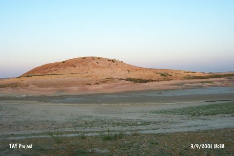 |
|
Type:
|
Mound |
|
Altitude:
|
560 m |
|
Region:
|
Southeastern Anatolia |
|
Province:
|
Sanliurfa |
|
District:
|
Bozova |
|
Village:
|
Tatarhüyük |
|
Investigation Method:
|
Excavation |
|
Period:
|
Late |
|
|
|
 |
|
| The mound is located northwest of Sanliurfa; 9 km northeast of Bozova district; below Tatar village. The 24 m high mound lies on the bank of Incesu stream today; in its previously wider valley. The base of the mound measures 500x200 m; while the cone is 150x110 m. Quite serious destruction is observed on the mound investigated in 1975 by Ü. Serdaroglu as a part of the Lower Euphrates Survey and in 1977 by M. Özdogan. Excavated in 1979 for a short while by Ü. Serdaroglu; the mound is visited again in 1982-84 by Kurban Höyük excavation team and investigated again for a short while by A. Misir from Urfa Museum and H. Hauptmann. The Chalcolithic Age pottery finds are in dark faced burnished ware; non-burnished ware; chaff-faced ware; light colored fine ware; and painted ware. Other finds date to EBA; MBA; IA; and Post-Classical periods. The location code is U 51 / 8. It takes place in the registered archaeological sites list prepared by Ministry of Culture and Tourism. |
| Location: |
| Geography and Environment: |
| History: |
| Research and Excavation: |
| Stratigraphy: |
| Small Finds: |
| Remains: |
| Interpretation and Dating: |