|
©The Archaeological Settlements of Turkey - TAY Project
|
|
|
|
|
|
Tarmil Höyük |
|
|
For site maps and drawings please click on the picture...  |
For photographs please click on the photo... 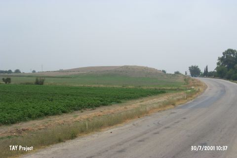 |
|
Type:
|
Mound |
|
Altitude:
|
120 m |
|
Region:
|
Mediterranean |
|
Province:
|
Adana |
|
District:
|
Kozan |
|
Village:
|
Ufacikören |
|
Investigation Method:
|
Survey |
|
Period:
|
Ceramic |
|
|
|
 |
|
| Location: The mound lies 3.8 km northwest of Ufacikören Village; approximately 12.5 km southwest of Kozan District; 84 km northeast of Adana Province. |
| Geography and Environment: The mound is fairly large in size. It has a 90x70 m base and is between 25 and 30 m high. It lies in a small plain fed by Kurucuoglu Stream. In some publications; the site has been called Termel or Tirmir. Southeast of the mound cemetery of the village takes place. |
| History: |
| Research and Excavation: The site has been researched in 1986 by Neilson; in 1951 by M.V. Seton-Williams; in 1959 by U.B. Alkim and in 1961 by the French Archaeological Institute. It takes place in the registered archaeological sites list prepared by Ministry of Culture and Tourism. |
| Stratigraphy: Although not definite; the surface finds from this site have been assigned to the Neolithic; Chalcolithic; Early Bronze Ages and the second millennium BC. A few Byzantine sherds are reported to have been found. |
| Small Finds: Pottery: Seton-Williams reports that the burnished ware found at this site resembles Late Neolithic Mersin Yumuktepe ceramics [Seton-Williams 1954:169]. No other information has been provided. |
| Remains: |
| Interpretation and Dating: Although this site is represented in Mellaart's map of Neolithic sites [Mellaart 1958a: map on page 82]; the validity cannot be ascertained since the finds have not been published. In ASPRO; the site has been assigned to a pre-Halaf period and has been placed in phase 6/2 [Hours et al. 1994:336-337]. |