|
©The Archaeological Settlements of Turkey - TAY Project
|
|
|
|
|
|
Asitepe |
|
|
For site maps and drawings please click on the picture...  |
For photographs please click on the photo... 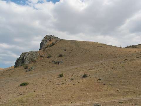 |
|
Type:
|
Flat Settlement and Workshop |
|
Altitude:
|
550 m |
|
Region:
|
Black Sea |
|
Province:
|
Amasya |
|
District:
|
Suluova |
|
Village:
|
Dereagil |
|
Investigation Method:
|
Survey |
|
Period:
|
|
|
|
|
 |
|
| The site lies northwest of the city of Amasya; 800 m southeast of Suluova District and of Dereagil Village. It lies southwest of a deep valley formed by the Kanlipinar Stream originating from the foothill of Tüllüçal Tepe. During the surface collection; sherds dating from the Chalcolithic to the Iron Age were recovered. |
| Location: The site lies northwest of the city of Amasya; 800 m southeast of Suluova District and of Dereagil Village. Asitepe is a local name; it was not given by the researcher. |
| Geography and Environment: The site lies southwest of a narrow valley formed by Kanlipinar Stream; which flows from the ridges of Tüllüçal Tepe; between the slopes of Yassiçal Sirtlari and Keltepe. The eastern side is partially destroyed by a small creek. The dimensions of the site are not reported according to the distribution of the finds. The abundance of flintstone suggests that Asitepe may be a workshop. A survey was made around the site for any flintstone sources. Consequently; a flintstone field was discovered in Aydoganlar Mevkii; approximately 1 km southeast of Asitepe. This quarry was probably used by Asitepe. Asitepe does not have a suitable location for a settlement. No fresh water springs are known to be present around the site except for the creek passing under. |
| History: |
| Research and Excavation: |
| Stratigraphy: |
| Small Finds: |
| Remains: |
| Interpretation and Dating: |