|
©The Archaeological Settlements of Turkey - TAY Project
|
|
|
|
|
|
Samsat |
|
|
For site maps and drawings please click on the picture... 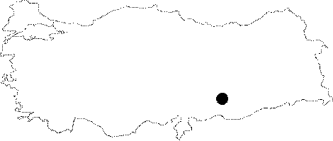 |
For photographs please click on the photo...  |
|
Type:
|
Mound |
|
Altitude:
|
425 m |
|
Region:
|
Southeastern Anatolia |
|
Province:
|
Adiyaman |
|
District:
|
Samsat |
|
Village:
|
Samsat |
|
Investigation Method:
|
Excavation |
|
Period:
|
Early Late Middle |
|
|
|
 |
|
| Location: The site; previous to its inundation by Atatürk Dam; used to lie in Adiyaman; Samsat District; just northeast of the center of the district. It survived as an island for a while after the formation of the dam's water reservoir since it was quite a high mound. The location code is T 51 / 14. |
| Geography and Environment: The mound founded as a settlement on Euphrates' bank; became an inland settlement; 700 m away from the river as a result of the geological oscillations in the river bed; previous to the inundation. The 37-40 m high mound consists of a large mound cone; surrounding terraces; and a lower city; it measures 500x350 m at the base. The mound gets very steep at the east and is sloped at the southwest. It stands upon an elevation of pebble fill as is observed in the sections seeing the river. The east terrace; where the Chalcolithic Age assemblage; is distributed intensely is thought to be the earliest mound. The settlement; known by the names of Samosate; Samosatum; then Semisat and Sumaisat in the Classical Ages; is located at the broadest section of the coastal plain and is therefore at the most advantageous point for crossing over the river. There are numerous fresh water springs at the relatively smooth slopes joining the plain with the plateau. Samsat is a considerable site with such geographical properties; settled in all ages since prehistory until recently. |
| History: |
| Research and Excavation: Samsat was excavated in 1964 and 1967 under T. Goell during a survey conducted for the Kingdom of Commagene in the Adiyaman region. Two trenches were dug: one broad trench in East-West axis on the cone and one stepped-trench at the eastern slope. It was renown even before the excavation. Then it is surveyed in 1975 by Ü. Serdaroglu and in 1977 by M. Özdogan as a part of the Lower Euphrates Basin Survey Project for investigating the sites endangered by Atatürk and Karakaya Dams of the Southeastern Anatolia Project (GAP) and it was reported that the site had been inhabited continuously from the Halaf Period to the Ottoman Period [For details; see: Harmankaya et al. 1998:Samsat]. It was excavated between 1978 and 1987 (except for 1980) under N. Özgüç aiming largely to open the layers of late period until it was submerged. The excavation was carried out in 7 sites of the large settlement like lower city; fortifications; midst of the eastern slope; southwestern section and the top hill; etc. The EBA levels were largely reached in the squares d-f/13-18 called southwestern trench. |
| Stratigraphy: The earliest settlement at the mound is from Halaf Period followed by Ubaid Culture. Besides the sherds collected during the surface surveys; the cultural deposit from these periods is recovered by N. Özgüç in a limited area in the 5 m deep sounding below the fresh water spring at the east of the mound [Özgüç (N) 1988:294]. And yet these levels yield no architectural remains. Uruk Period settlement of the mound is excavated in a broader area and it is reported that Early Bronze Age; Middle and Late Bronze Age; Iron Age; Classical Period; and Post-Classical Period remains are superimposed on this earlier level. In Iron Age; Samsat was at first the centre of the Late Hittite Kingdom of Kummuh and then was taken over by the Urartu before becoming a state in the Assyrian confederation. Hegemony of Meds; Persians and Alexander the Great in this city have followed this period. It has then become the centre of Commagene and then a state in the Roman Empire. Then; being a centre of political conflict between Byzantion and Arabs; it has become the centre of a Turkmenian principality; a county of the Crusaders; an independent Armenian county; an Artukid and an Eyyubid city until it was taken over by the Ottomans in the 14th Century. |
| Small Finds: Architecture: The broad and thick layers of Halafian and Ubaid settlements; rich in find; are recovered in the surface survey; but they could not be excavated broadly and no architectural remains could be recovered in the excavated areas [Özgüç (N) 1988:294]. Late Chalcolithic: It is observed that the Medieval Age fortification has its foundation directly on the Early Bronze Age level; cutting through the levels of Iron Age; LBA; and MBA; on the eastern slope of the mound overseeing Euphrates. Levels XX-XXVII are of the Samsat settlements that are interrelated with Uruk Culture. The fortification wall recovered from Level XXIV is built directly on Level XXV. The Level XXV structures are two-roomed buildings with stone foundation. Wall basements and a pebble-paved floor are the architectural remains of Level XXVI. On the other hand; excavations at the southeastern section of the mound have revealed that Level XX is the strata connecting Late Chalcolithic and EBA. The first course of the stone foundation of a two-roomed structure is recovered in the limited excavated area [Özgüç (N) 1988:293]. The front room is smaller. Pottery: The Halafian and Ubaid pottery is evaluated in three groups [Özgüç (N) 1988:294]: dark-faced burnished; dark-faced non-burnished; and painted wares. The painted consist of the Halafian and Ubaid types. The Late Chalcolithic Age pottery is either produced on common or slow-wheel or are hand-made. The hand-made forms are bowls; shallow bowls; small vases; bowls with pedestals; and spouted jugs. The conical* vessels with flat rims; flat bases and bevelled rim bowls are recovered abundantly in all Late Chalcolithic levels. Also; reserved-slip decorated sherds are recovered [Özgüç (N) 1988:294]. Clay: Besides the spindle-whorls; weights; and androns; clay cones that are typical Uruk architectural decoration elements are recovered from the Late Chalcolithic Age levels [Özgüç (N) 1988:294; Özten 1984:263]. Chipped Stone: It is reported that numerous cores; flakes; and tools out of flint and obsidian are recovered together with Ubaid and Halaf sherds from the sounding on the eastern slope of the mound [Özten 1984:261]. The Late Chalcolithic tools such as blades; scrapers; and arrowheads are mostly out of flintstone; obsidian is recovered rarely [Özgüç (N) 1988:293]. Ground Stone: In the Late Chalcolithic levels; spindle-whorls out of stone; rings; a limestone wheel; clover-shaped beads; and decorated stamp seals are recovered. One of these has two animal figures on one side and fish-bone decoration on the other; while another depicts three seated animals. Another; in the shape of a squat cylinder; depicts two animals arranged in a coat of arms. Another extraordinary seal has inlayed ivory in the shape of a triangle on the flat side and of a circle on the backed side. Two interesting finds are a violin-shaped idol and a greenish gray beaker out of steatite [Özgüç (N) 1988:293-294; Özten 1984:262]. Bone/Antler: Bone pins and spindle-whorls are recovered from the Late Chalcolithic levels [Özgüç (N) 1988:294]. Metal: A bronze pin was recovered from Level XX; southwest of the mound [Özgüç (N) 1988:293]. Human Remains: The infant burials of the Late Chalcolithic Age are recovered in jars; pithoi; and pits. They are covered by deep plates used as lids. Some contain goods such as beads; bracelets; and vessels. The beads are out of limestone and pierced animal teeth; the bracelets are made of obsidian; red stone; and limestone [Özgüç (N) 1988:294]. |
| Remains: |
| Interpretation and Dating: Chalcolithic Age and Iron Age layers constitute most of the deposit of the mound cone. Considering the level at which the sherds on the eastern slope were recovered; it is assumed that 20 of the 40 m cultural deposit belongs to the Chalcolithic Age. The recent research has proved that the habitation of Samsat begins in Halaf Period; although in the sixties; Ubaid Period was considered to be the first settlement [Orthmann 1968/69:140]. The typical Halaf; Ubaid; and Uruk finds suggest that the site must have been an important centre in these periods. And yet the mound has been inundated before it was possible to excavate the deposit of these layers. |