|
©The Archaeological Settlements of Turkey - TAY Project
|
|
|
|
|
|
Samanköy |
|
|
For site maps and drawings please click on the picture...  |
For photographs please click on the photo... 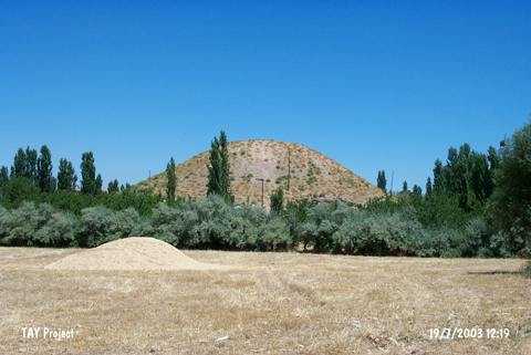 |
|
Type:
|
Mound |
|
Altitude:
|
860 m |
|
Region:
|
Eastern Anatolia |
|
Province:
|
Malatya |
|
District:
|
Merkez |
|
Village:
|
Samanköy |
|
Investigation Method:
|
Survey |
|
Period:
|
|
|
|
|
 |
|
| It is located in a valley; 1.1 km south of the village it was named after; northwest of Malatya Province. There are trees around the mound and the dirt road to Bahçeköy Village passes on west-northwest skirt. It is a medium sized mound. It measures ca. 20 m in height and 75 m in diameter. During a survey conducted by C.A. Burney; aside the material of Chalcolithic Age; sherds of the black burnished Karaz ware; the red-brown burnished ware and the painting decorated ware were collected from the surface. Von der Osten who visited the site in 1927 calls it Samam. It takes place in the registered archaeological sites list prepared by Ministry of Culture and Tourism. |
| Location: |
| Geography and Environment: |
| History: |
| Research and Excavation: |
| Stratigraphy: |
| Small Finds: |
| Remains: |
| Interpretation and Dating: |