|
©The Archaeological Settlements of Turkey - TAY Project
|
|
|
|
|
|
Asagi Pinar |
|
|
For site maps and drawings please click on the picture...  |
For photographs please click on the photo... 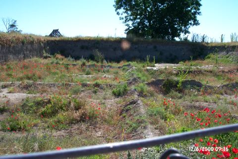 |
|
Type:
|
Mound |
|
Altitude:
|
130 m |
|
Region:
|
Marmara |
|
Province:
|
Kirklareli |
|
District:
|
Merkez |
|
Village:
|
Merkez |
|
Investigation Method:
|
Excavation |
|
Period:
|
|
|
|
|
 |
|
| The site lies south of the city of Kirklareli; on the east side of Asibeyli village road; across the town slaughterhouse. It was discovered during the survey around the Thrace and Marmara Region conducted by M. Özdogan; and published as Salhane in 1980. The mound is also cited as Kirklareli Höyügü in some publications [Özdogan et al. 1997b:53].Haydardere stream passes making curves in the north and west of the mound. There is a spring with a strong current right west of the mound on the area used for recreational purposes. The upper levels of the mound that possibly belong the Late Ancient Age, were heavily destructed due to the construction of a tumulus. A 40 cm thick, plastered enclosing wall was constructed, which was fortified with wooden sticks and which measures 38 m in diameter. Part of the soil necessitated for the constitution of the Tumulus was possibly drawn from the skirts of the mound, the loamless soil was transported from other locations. It was assumed that this tumulus was possibly completely leveled by the Russians who invaded the Kirklareli region during the 19th century in order to unearth the valuable burial presents. Due to the unveiling of the finds between Late Neolithic Age and 4th century BC according to the chronological sequence of the culture in the Balkans, inside and around the mound. Before the construction of the tumulus it might have been a mid-size mound [Özdoğan-Parzinger1995:51]. |
| Location: The site lies south of the city of Kirklareli; on east side of Asibeyli village road; across the slaughterhouse of the town. It was discovered during the survey around Thrace and Marmara Region conducted by M. Özdogan; and published as Salhane in 1980. The mound is also cited as Kirklareli Höyügü in some publications [Özdogan et al. 1997b:53]. |
| Geography and Environment: Haydardere Stream runs through the north and west of the site. A spring with a strong flow rate is located at the west. The upper levels were probably destroyed by a tumulus that was built on top of the mound in the Late Antiquity. 40 cm thick; plastered enclosure wall; measuring 38 m in diameter and consisting of wood stakes; was built to prevent the soil erosion. The necessary soil for the construction of the tumulus was probably taken from the lower parts of the mound. Loamless soil was brought from other sources. It is interpreted that this tumulus was flattened for its valuable grave goods by the Russians invading Kirklareli in the Late 19th century. Finds; dating back from the Late Neolithic Age to the 4th century BC according to the Balkan chronology; were found at the site. This shows that the mound was medium in size before the tumulus was built [Özdogan-Parzinger 1995:51]. The excavation area is bordered with barb wire and the local house models built during the excavations can still be seen on the site. The new trenches are covered with wooden beams for protection. |
| History: |
| Research and Excavation: |
| Stratigraphy: |
| Small Finds: |
| Remains: |
| Interpretation and Dating: |