|
©The Archaeological Settlements of Turkey - TAY Project
|
|
|
|
|
|
Asagi Pinar |
|
|
For site maps and drawings please click on the picture...  |
For photographs please click on the photo... 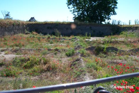 |
|
Type:
|
Mound |
|
Altitude:
|
130 m |
|
Region:
|
Marmara |
|
Province:
|
Kirklareli |
|
District:
|
Merkez |
|
Village:
|
Merkez |
|
Investigation Method:
|
Excavation |
|
Period:
|
Middle |
|
|
|
 |
|
| Location: The site lies south of the city of Kirklareli; on east side of Asibeyli village road; across the slaughterhouse of the town. It was discovered during the survey around Thrace and Marmara Region conducted by M. Özdogan; and published as Salhane in 1980. The mound is also cited as Kirklareli Höyügü in some publications [Özdogan et al. 1997b:53]. |
| Geography and Environment: Haydardere Stream runs through the north and west of the site. A spring with a strong flow rate is located at the west. The upper levels were probably destroyed by a tumulus that was built on top of the mound in the Late Antiquity. 40 cm thick; plastered enclosure wall; measuring 38 m in diameter and consisting of wood stakes; was built to prevent the soil erosion. The necessary soil for the construction of the tumulus was probably taken from the lower parts of the mound. Loamless soil was brought from other sources. It is interpreted that this tumulus was flattened for its valuable grave goods by the Russians invading Kirklareli in the Late 19th century. Finds; dating back from the Late Neolithic Age to the 4th century BC according to the Balkan chronology; were found at the site. This shows that the mound was medium in size before the tumulus was built [Özdogan-Parzinger 1995:51]. The excavation area is bordered with barb wire and the local house models built during the excavations can still be seen on the site. The new trenches are covered with wooden beams for protection. |
| History: |
| Research and Excavation: The archaeological sites in Kirklareli are in danger because of the rapid urbanization. The excavation of Asagi Pinar is conducted by M. Özdogan and H. Parzinger since 1993. It is reported that an area of 2000 m squares was dug at the site according to the results of 1997 excavation. |
| Stratigraphy: The stratigraphy has been almost revealed after 5 years of study. The deposit of the tumulus; plundered by the Russians; the soil; carried from and around the mound for the construction of the tumulus; and the remains of the enclosure wall were encountered in the first level of the mound. Below this complicated deposit is the second level; which is slightly damaged by the Iron Age pits. It is observed that the structures; lined up regularly with the wide open areas between them; were sheltered by an enclosure wall. Although the settlement arrangement of the 3rd and 4th levels is similar to the second level; buildings are rare in this level. The settlement arrangement of the 5th level is different from the upper levels. The houses were built on a regular plan. The village at this level is surrounded by a ditch. The buildings; dating back to the Late Neolithic Age-Early Chalcolithic Age; are very close or clinged together at the 6th level. Other levels are dated back to the Early and Middle Chalcolithic Age of the chronology of Anatolia. The chalcolithic deposits at Asagi Pinar are located mostly in the center and south section of the mound [Özdogan (E) et al. 2008:47]. A displacement towards the south was identified on the settlement which was founded on the north section and developed in that direction as well [Özdogan et al. 2009:234]. Stratification on the mound: Neolithic Period (8th-6th levels; 6400-5700 BC) Transition Period (Neolithic-Chalcolithic Transition) Chalcolithic Period (5th-1st levels 5500-4800 BC) [Özdogan et al. 2009:233]. |
| Small Finds: Architecture: Architectural remains were not observed at the first level; damaged by the Iron Age pits. The two-roomed structures stand independently in the 2nd level. The wattle-and-daub structures are supported with wooden studs. The floors are wooden; and there are ovens and fireplaces. In addition; depots made of clay slabs were observed. Structures in the same technique were recovered from the 3rd level. The floors of the houses in the 4th level are made of clay. There are also larger structures with supporting wooden studs. The walls of the 5th level are thin. Wooden studs are placed at the external side of the bearing walls. The non-loadbearing walls resemble a fence plastered on both sides. The structural remains of the 6th level are well preserved since they were conflagrated. Structures contain wooden lintels and thick walls supported by studs. Oven remains in the back rooms and storage pits were recovered. The building techniques of the Chalcolithic Age structures of Asagi Pinar are very similar to the techniques in Southeastern Europe [Özdogan 1998:73-76]. During 2005 season excavations west part of the building remain in layer 4 was also uncovered. Finds from this wattle building indicated that it was used for storage. 7 in-situ silos with the diameters were changing from 75 cm to 25 cm were found. The grain remains found in silos and on the floor showed that these storage units were full. Also the excavations carried on at the trench which the enclosing wall of layer 4 was crossing. This showed that the settlement was extending to the east in Chalcolithic Age; but damaged in Iron Age [Özdoğan-Schwarzberg 2006:16]. The level 5 architecture observed during the excavations performed in 2005 is a similar type of structure observed in level 5 of both the North Excavation Area and the other area called the "Central Area". Those buildings found by reaching the basin level consist of structures with clay floors; thin walls made possibly with branch plaids plastered with clay [Özdogan (E) et al. 2007: 259]. New fiindings were encountered in the north section of the 2007 excavations, which are related to the Chalcolithic Period architecture and it was observed that levels 4 and 5 were somewhat different compared to the one in the south. There are single cell domestic buildings elaborately placed at 1 m intervals, in southeast-northwest direction. Inside the building a hearth adjacent to the north wall and outside fire places, small storage rooms were observed. But these buildings display a dispersed view unlike the one in the south in terms of the utilisation of the open-air areas and their order. Although not as good as the level 5 structures the level 4 buildings also display a neat view but they were placed dispersed in the north section [Özdogan et al. 2009:239-240]. Structure remains possibly belonging to level 5 were found during 2008 excavations in the north section. A total of 11 structure remains found inside this level suggest that level 5 extends between the north of the mound and the south of the mound [Özdoğan (E) et al. 2010:362]. Pottery: Sherds; resembling Karanovo IV and Early Maritsa Culture; were found at the first level. Sherds of dark-faced; white incrustated; incised or fluted wares were recovered from the 2nd level. This level's pottery is contemporary with the Middle and Late Karanovo IV. Anthropomorphic vessels are the two extraordinary finds of this level. One of them with two lobes and a short neck resembles a woman. There are relief decorations with religious implications on it. Another one is shaped like a man; wearing skirt and sitting on a chair with four legs and a high back. Similar finds of the first vessel are observed at Hacilar; and of the second vessel at Middle Danube. Dark-faced; high-necked and carinated jars; wide bowls; plates; and vessels with small pedestals were recovered from the 3rd level. Some of them are incised; fluted; and relief decorated. According to Özdogan; these resemble the Vinça traditional ware [Özdogan 1975:75]. In adittion; there are vessels with coarse surfece; resembling Karanovo IV. Incised broken lines are observed on the dark gray-brown ware of Toptepe tradition. Single-handled; hollow mouth; and carinated jars; and high pedestals with windows* are the typical forms of this ware. Wares; resembling the Early Vinça-Veselinovo sherds of Balkan chronoloy; were recovered from the 4th level. Surface colors are almost black. Bowls; carinated at the neck and belly; plates; and rectangular vessels are the most common forms. Horn handles; white incrustated incised and excised decorations hint the existence of a settlement contemporary with Karanovo III. Dark colored; very coarse sherds were found at the 5th level; which is contemporary with Proto-Vinça Period according to Özdogan. There are red slipped sherds as well as black ware at the 6th level; which is contemporary with Karanovo II and Ilipinar VI. Clay: A baked clay headless woman figurine with her arms on her chest; a broken figurine with exaggerated hips; and a cult table with decorated feet were recovered [Özdogan et al. 1997b:fig.21; 20; 19]. Chipped Stone: Surprising results were acquired by the analysis that finished at the end of 1995 excavation season. Although blade industry is dominant at the 4th -5th levels; microlithic tradition emerges at the 3rd level. The reason of this reverse development is not known. Bone / Antler: A bone object; identified as a figurine; is reported. It is covered with small holes [Özdogan et al. 1997b:fig.22]. Fauna: It is observed that animals were hunted as a result of the region being covered with steppes and that cattle was more important than sheep and goat. |
| Remains: |
| Interpretation and Dating: Asagi Pinar excavations have yielded significant information about Thrace archaeology. These finds have enlightened at least one period of this region that was not known in the 60s. According to the carbon samples level 3 can be dated to 6300 BC. The 14C samples of Asagi Pinar have defined the places of Thrace cultures in the chronology of the Balkans. 14C results and the comparisons are as follows: Level 1: 5.850-5.800 BP Karanovo IV last phase Level 2: 6.150-6.000 BP Karanovo IV middle and partly last phase Level 3: 6.300-6.200 BP Toptepe and Karanovo IV Level 4: 6.350-6.300 BP Karanovo III Level 5: 6.400-6.350 BP Karanovo III-II transition; Proto-Vinça; Hoca Çeşme II Level 6: There are no 14C samples. Karanovo II; Ilıpınar VI. The excavations performed on level 4 during 2006 campaign suggested that the in situ items were dispersed so that they do not allow people to live or even walk around inside, therefore the building could possibly not be a domestic building. But it was more like a workshop or warehouse. But the lack of finds or findings to show a specific work was performed suggests that the shelter problem could have been resolved using mezzanines [Özdogan (E) et al. 2008:48]. |