|
©The Archaeological Settlements of Turkey - TAY Project
|
|
|
|
|
|
Naltepesi |
|
|
For site maps and drawings please click on the picture...  |
For photographs please click on the photo... 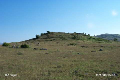 |
|
Type:
|
Upland Settlement |
|
Altitude:
|
1440 m |
|
Region:
|
Black Sea |
|
Province:
|
Ordu |
|
District:
|
Mesudiye |
|
Village:
|
Karabayir |
|
Investigation Method:
|
Survey |
|
Period:
|
Late |
|
|
|
 |
|
| The site is located southwest of Ordu; 2 km northwest of Karabayir village that lies approximately 12 km west-northwest of Mesudiye. The settlement is on a natural hill in the middle of a watery plain 500 m south of Ziyaret Tepesi. The name of the settlement is derived from the name of the hill it is on. Intense illicit digging is observed. From the surface; Late Chalcolithic Age; EBA; and 1st Millennium BC painted Phrygian sherds are collected by M. Özsait; who has discovered the site in 1990. |
| Location: |
| Geography and Environment: |
| History: |
| Research and Excavation: |
| Stratigraphy: |
| Small Finds: |
| Remains: |
| Interpretation and Dating: |