|
©The Archaeological Settlements of Turkey - TAY Project
|
|
|
|
|
|
Musular |
|
|
For site maps and drawings please click on the picture... 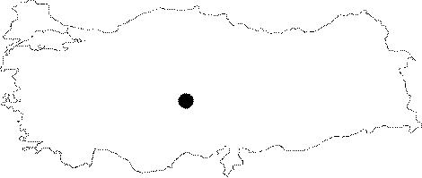 |
For photographs please click on the photo... 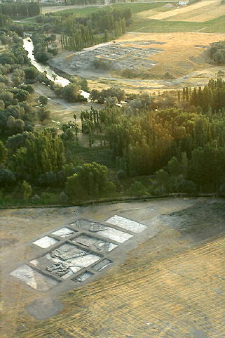 |
|
Type:
|
Flat Settlement |
|
Altitude:
|
1145 m |
|
Region:
|
Central Anatolia |
|
Province:
|
Aksaray |
|
District:
|
Gülagaç |
|
Village:
|
Kizilkaya |
|
Investigation Method:
|
Excavation |
|
Period:
|
Aceramic Ceramic |
|
|
|
 |
|
| Location: This site of Musular lies in the province of Aksaray; 1 km south of the village of Kizilkaya; district of the Gülagaç Municipality. About 18 km after the Aksaray-Nevsehir road turns south from the Güzelyurt-Ihlara turning; there is a road to Gülagaç district and Demirci Beldesi. The site can be reached by following the road to right; about 500 m after this turning. Musular Mevkii lies to the west of Melendiz River and it is about 300-400 m far from Asikli Höyük. Code P 33/8. |
| Geography and Environment: Musular lies in a volcanic area north of Mount Hasan and the Melendiz Mountains; in the fertile Ihlara Valley; on the western shore of Melendiz Stream. It is located immediately west of the Aceramic Neolithic site of Asikli. Agricultural activities are still being carried out in an area outside the excavation area but which actually is included in the settlement. The open-air site lies on a rock outcrop and extends over a 220x120 m area. The highest point of the site is at an attitude of 1120 m above the sea level [Özbasaran 1999:149]. It lies on the tuff formatted bedrock and the bedrock can be seen on the surface in some areas. |
| History: |
| Research and Excavation: The site was discovered in 1993 during the Anatolian Cultural Inventory Project led by the Asikli Höyük excavation team of the University of Istanbul Department of Prehistory [Gülçur 1995a: 153-154; 1995b: 193]. The site was revisited and researched in 1994 and 1995 by S. Gülçur during the Cappadoccia Survey. Excavations at the site were carried out during 1996-2004; under the direction of the Aksaray Museum and a team consisting of from the Prehistory Department of University of Istanbul. It takes place in the registered archaeological sites list prepared by Ministry of Culture and Tourism. |
| Stratigraphy: Two main occupational phases were determined in Musular. The first settlement lying on the bedrock belongs to the Aceramic phase of the Neolithic Period and is dated between 7500-6500 BC (cal.). The Aceramic Neolithic settlement; which has five layers as far as it has been excavated; is contemporary and related to the upper phases of Asikli Höyük. Above the Aceramic settlement; the Ceramic phase settlement lies but its date has not been clarified yet. It lies partially on the Aceramic fill and on a ground level; which was gained by leveling the buildings of the Aceramic settlement. It was determined that the two of the occupational phases are located on the slightly high southern section due to the sloping bedrock topography of Musular. The relatively flat section of the settlement to the north is included in the activity area of the Aceramic Neolithic settlement. |
| Small Finds: Architecture: The architecture of the Aceramic Neolithic phase is constructed directly on the bedrock. The earliest layer is represented by a pit of the bedrock which was used as a trash pit of bone storage. Mostly very large cattle bones were put in this pit. After a period of time; the pit was covered with a thick yellowish white soil and leveled. Immediately after; partially over this level and partially over the bedrock; a building with mudbrick walls and stone foundation was constructed. The purpose of this building has not been determined yet; but it was understood that the west of it was used as an open-air workshop or an open-air area. Above this level; the level represented by a stone channel with a splendid construction; which was determined to be covered once; a two roomed structure with stone foundation and remains of red plastered floored buildings; was encountered. Above these layers of Aceramic Neolithic Period; although not being clarified yet; layers that can be dated to the end of the Neolithic or the beginning of the Chalcolithic take place. The building remains recovered from the Aceramic Neolithic settlement and the preliminary results of the other ongoing analysis indicate that Musular was inhabited due to a special function/functions. The settlement; which is contemporary to the last structural phases (a-c) of the second layer or to the first layer of Asikli Höyük; was probably used/inhabited for a specific purpose by the inhabitants of Asikli Höyük or by a group that has left the site. The architectural remains of Musular; especially the usage of stone; which starts in the last phases of Asikli Höyük; stone workmanship; rectangular buildings with red plastered floors make this consideration possible [Özbasaran 1999: 149-150] [Özbasaran 2000a: 133-135][Özbasaran 2000b: 46]. During 2003 season excavatons archaeological layers observed at a 2-2.5 m high section in the field about 50 m north of the northern border of the site. This area named as Ven 7 and in a trench of 2x1 m dimensions 0.75 m of archaeological deposit excavated by 10 units. Most of the material from this area were animal bones; in the second place obsidian tools and debitage were found and there were also three awls and worked/used bone among the finds. Architectural remains were not found and the first results and observations suggested that the area could be a midden [Özbasaran et al. 2006:243-244]. Chipped Stone: Most of the Musular chipped stone industry consists of obsidian. The first evaluations have shown that the source of the obsidian is Nenezi and Göllüdag. It was understood that; the obsidian was coarsely cleaned and shaped and brought to the settlement as large blocks. The main purpose of the industry was probably to produce parallel sided; flat profiled blades. The usage of these blades for making arrowheads was verified by the numerous examples found. Typologically; the points take the first place among the tools; the two main types consist of pressure retouched and a little number of Byblos-like shouldered points. Other tools are scarpers; retouched blades; pieces and a few perforators and burins [Balkan-Atli 1998: 92] [Özbasaran-Endogru 1998:206] [Özbasaran 1999: 152] [Özbasaran 2000a: 136]. Ground Stone: Several flat axes; whet stones; stone bowl fragments; hammer stones; which were thought to be used for obsidian production; were found [Özbasaran-Endogru 1998:207]. Bone/Antler: Musular bone industry is not rich in variation. The most common tools are awls. A small number of neatly made examples are available [Özbasaran-Endogru 1998:207][Özbasaran 2000a:137]. A very little number of antlers were used as tools. Human Remains: During the excavations between 1996-2000; 8 skeletons were encountered. Four of these were found in situ; three were scattered. One of them is only represented by a jaw bone. The well preserved ones indicate that the burials were placed in hocker position and there were not any grave goods. Three of the burials belong to the Aceramic Neolithic; the others belong to later phases and were buried into pits; which were dug into the Aceramic Neolithic fill [Özbasaran 2000a:137-138][Özbek1998:161-173]. Fauna: Animal bones generally consist of two main groups: sheep-goat and cattle. 42% of the identified pieces belong to gaurs; this is followed by bezoar goat; wild sheep; wild boar; horse and deer. Foxes and rabbits are the other group. Analysis have given results showing that the inhabitants of Musular had the ability to control the wild goats; sheep and cattle; and that they chose the necessary or needed ones from the animal species [Özbasaran et al 2003: 262-264][Buitenhuis 2001]. Flora: A very small amount of plant remains were encountered; among these the presence of cultivated barley and wheat is known. The detailed analysis of the peas; fruits; wild plants and grass are being carried out [Özbasaran 2000a:138]. |
| Remains: |
| Interpretation and Dating: According to the preliminary observations of the materials and the 14C results; the Aceramic Neolithic site of Musular is contemporary to the late phases of Asikli Höyük: GrN-23518:7.980 ±220; GrN-24918: 8.300±90; GrN-24923: 8370±110; GrN-24924: 8420±110 (calibrated BP dates). Considering the presence of two other different Aceramic Neolithic find spots in an area of 1 km; it can be suggested that after the inhabitance of Asikli Höyük; the settlement pattern of the region has changed and the Asikli settlement has formed satellite settlements. Besides Musular and Asikli; which are currently being excavated; after the researches of the other sites; this change at the end of the Aceramic Neolithic period can be understood completely [Özbasaran 2000b: 44]. Musular obsidian industry also has some similarities with the other Aceramic Neolithic settlements of the region; especially Sirçan Tepe [Balkan-Atli 1998:84]. |