|
©The Archaeological Settlements of Turkey - TAY Project
|
|
|
|
|
|
Misis |
|
|
For site maps and drawings please click on the picture...  |
For photographs please click on the photo... 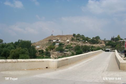 |
|
Type:
|
Mound |
|
Altitude:
|
50 m |
|
Region:
|
Mediterranean |
|
Province:
|
Adana |
|
District:
|
Merkez |
|
Village:
|
Yakapinar |
|
Investigation Method:
|
Excavation |
|
Period:
|
Ceramic |
|
|
|
 |
|
| Location: This site lies in Yakapinar (Misis) Subdistrict; east of the city of Adana. It appears on all touristic maps because it was a Roman and Byzantine city. |
| Geography and Environment: The large mound of Misis lies on a natural ridge along the Ceyhan River. There was a Roman-Byzantine city on both sides of the Ceyhan River; especially on the western bank. |
| History: |
| Research and Excavation: The Roman ruins at the site of Misis (known in antiquity as Selevkia in Pyramus) has attracted many visitors and researchers. A survey was conducted at the site in 1951 by Seton-Williams [Seton-Williams 1954:164-165]. Since 2012, excavations at Misis Höyük have been carried out by Adana Museum. Misis Höyük is listed as an officially registered archaeological site by the Ministry of Culture and Tourism. |
| Stratigraphy: In addition to the Byzantine and Roman Periods; the site was inhabited in the Iron Age; Late; Middle and Early Bronze Ages; the Chalcolithic Period and possibly in the Late Neolithic Period. |
| Small Finds: Pottery: Many incised pre-Halaf ceramics were found at the site. Detailed information on this ware has not been provided. It probably dates to the transitional phase between the Late Neolithic-Early Chalcolithic Periods. |
| Remains: |
| Interpretation and Dating: The Late Neolithic component of this site should be viewed with skepticism. The fact that the site lies along the Ceyhan River suggests that it was in a strategic and very ancient location and on a natural trade route between the Mediterranean shore and Central Anatolia via Kozan. In ASPRO; the site has been assigned to the sixth phase [Hours et al. 1994:240]. |