|
©The Archaeological Settlements of Turkey - TAY Project
|
|
|
|
|
|
Asarcik Höyük / Ilica |
|
|
For site maps and drawings please click on the picture...  |
For photographs please click on the photo... 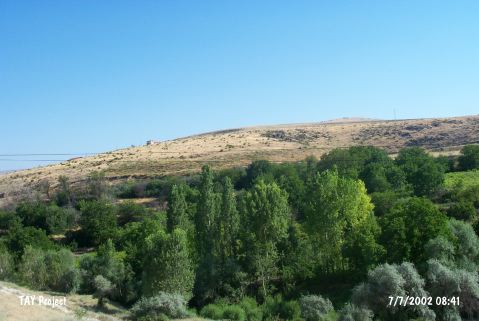 |
|
Type:
|
Mound |
|
Altitude:
|
770 m |
|
Region:
|
Central Anatolia |
|
Province:
|
Ankara |
|
District:
|
Ayas |
|
Village:
|
Ilica |
|
Investigation Method:
|
Excavation |
|
Period:
|
EBA III |
|
|
|
 |
|
| Location: It lies northeast of the Ilica Village; 9;5 km from northwest of the Ayas District; west of the Ankara Province. The Güdül - Ankara motorway is on the west of the village. |
| Geography and Environment: The northern part of the mound located on a basalt hill elevated by the accumulation of settlements [Orthmann 1966:plan I] faces the steep and abrupt valley of the Ilica Suyu. Asarcik Höyük is somewhat different than the other settlements since it is located between the two streams. The southern part is not as steep as the northern part. The stream of Ilica Suyu on the north; originating from the Kizilcabayir Dagi; presumably supplied water to the inhabitants [Kökten 1947:442]. |
| History: |
| Research and Excavation: The settlement was discovered by K.Kökten in 1945 [Kökten 1947:442]; and excavated by W. Orthmann of the German Archaeological Institute; Istanbul in 1963 and 1964. The excavations were carried out; aside Asarcik Höyük; in the extramural cemetery dating from the later period on the south of Ilica Köyü. It takes place in the registered archaeological sites list prepared by Ministry of Culture and Tourism. |
| Stratigraphy: Five layers were identified during the excavations; Layer I: Roman-Galat Period Layer II: Hellenistic Period Layer IIII: Last Phyrgian Period (Iron Age): The houses layer outside the fortification walls: Second half of the second millennium BC Layer IV: First half of the second millennium BC/Ancient Hittite Period Layer Va: Intermediate period (transition from EBA to the second millennium BC) Layer V: EBA III (phases II-III according to excavation leader) |
| Small Finds: Architecture: Although floors of level V dating from the EBA III were revealed; none of the trenches yielded adequate remains. This layer is represented best by the trench on the far north. The scanty wall remains reveal the presence of houses with stone foundations [Orthmann 1965:108-109; pic.10]. Pottery: Intact vessels; mostly belonging to the undecorated groups of ware were found in layer V. This layer includes samples of the washed; burnished and unburnished ware; colored varying between red and brown. Bowls with open rims and slightly round bottoms have globular bodies. They are rarely lugged. The handles of the cups reach over their rims [Orthmann 1966:fig.3/4]. Besides globular and semi-spouted pitchers; there are spouted pitchers. The handled vase represents an interesting type [Orthmann 1966:fig.5/4] with its globular body; upper part enlarging towards the rim. In addition; there are storage and cooking vessels (pithoi). Depas are limited in number. An object recovered from layer V; made of a ware found for the first time at Polatli Höyük and therefore so called Polatli ware washed in a color ranging from dark red to brown with a fine work; helps to date this layer [Orthmann 1966:fig.7/1-4]. Another sample of this layer is the pottery decorated with nail impression. The impressed decorations are applied on the rim of the dish or bowls in bands [Orthmann 1966:fig.8/2]. The incised decorations on the brown burnished vessels with black interiors and red exteriors; are filled with white paint. These are globular bowls with rounded bottoms [Orthmann 1966: fig.8/4-5]. There are beautiful samples of the painting decorated ware on a light background. The so called transition period of layer Va is dominated by the plain ware. The forms are not distinctive than the preceding layer. Forms of globular cups; flat cups; and depas are common. Also found are very small vessels [Orthmann 1966:fig.9/9-14]. Clay finds: Spindle-whorls were found [Orthmann 1966:pic.4/on the right]. Ground stone: Only the lower part of an idol in limestone was recovered. Metal: A small carinated; riveted and tangled dagger with a triangular blade was published. |
| Remains: |
| Interpretation and Dating: Although four trenches were opened; the EBA levels could not be reached extensively. Still; the finds and pottery industry of that culture were revealed. The layer V was dated to EBA II-III by the excavator and evaluated within the EBA cultures of the Central Anatolian Region while layer Va is suggested to be contemporary with Proto-Hittite level of Karaoglan Höyügü and pre-Hittite level of Bogazköy. It is compared with the settlements of Etiyokusu; Ahlatlibel; and Polatli. According to M. Korfmann; layer V is considered part of the second half of the EBA IIIa and IIIb [Korfmann 1989:chronological table on fig.3]. |