|
©The Archaeological Settlements of Turkey - TAY Project
|
|
|
|
|
|
Mercin / Boz Höyük |
|
|
For site maps and drawings please click on the picture...  |
For photographs please click on the photo... 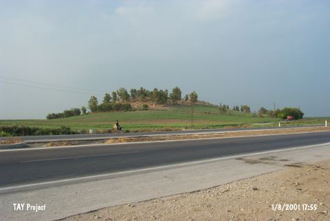 |
|
Type:
|
Mound |
|
Altitude:
|
90 m |
|
Region:
|
Mediterranean |
|
Province:
|
Adana |
|
District:
|
Ceyhan |
|
Village:
|
Incetarla |
|
Investigation Method:
|
Survey |
|
Period:
|
Late |
|
|
|
 |
|
| The mound lies northeast of Ceyhan River; southwest of Incetarla (Mercin) Village; on the old Ceyhan-Kadirli highway; 3 km north-northwest of Ceyhan District; east of Adana Province. The top of the mound; with a height of 20 m and a diameter of 160 m; is flat. It was discovered in 1936 by Nielsen Expedition and was explored again in 1951 by M.V. Seton-Williams during Cilicia Survey. Settlements from LBA to Roman Period is observed on the mound; whereas it is considered in the 9th phase in ASPRO. It was researched within the scope of "Adana (Ceyhan) and Kayseri (Develi) Surveys" performed by S. Girginer et al. in 2005. It was destructed due to the agricultural activities especially on the northeastern slopes and skirts; and the northern slopes and skirts were destructed due to the structuring. It is 40-50 m high; and 200x150 m wide. Silex and obsidian tools were unearthed along with a terra cotta weight; and pottery dating to Chalcolithic; EBA; and 2nd Millenium BC; and late periods [Girginer 2007:178]. It takes place in the registered archaeological sites list prepared by Ministry of Culture and Tourism. |
| Location: |
| Geography and Environment: |
| History: |
| Research and Excavation: |
| Stratigraphy: |
| Small Finds: |
| Remains: |
| Interpretation and Dating: |