|
©The Archaeological Settlements of Turkey - TAY Project
|
|
|
|
|
|
Maltepe / Burumcuk |
|
|
For site maps and drawings please click on the picture...  |
For photographs please click on the photo... 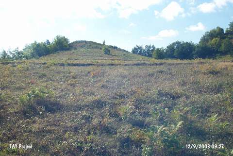 |
|
Type:
|
Mound |
|
Altitude:
|
605 m |
|
Region:
|
Black Sea |
|
Province:
|
Sinop |
|
District:
|
Gerze |
|
Village:
|
Boyali |
|
Investigation Method:
|
Survey |
|
Period:
|
|
|
|
|
 |
|
| It lies on the western bank of the Sarimsak Stream on the road running from Gerze to Boyali Village; about 15 km southwest of Gerze District. To the northwest is the Akçakese quarter of the village of Gürsökü; north-northeast the villages of Sazak and Boyali; to the south Burunkuzu Valley; and to the south-southeast Aktopraklik Hill. It was discovered during the Sinop Survey conducted by M.A. Isin. It measures 12 m in height and 100 m in width. It has been damaged due to heavy cultivation and illicit digging. Pottery of the EBA and the Late Roman Period was collected from the surface. The EBA pottery is of burnished ware with a grit; seashell and plant tempered paste. Surface colors vary between red; black; brown and buff. Forms of bowls are common. It takes place in the registered archaeological sites list prepared by Ministry of Culture and Tourism. |
| Location: |
| Geography and Environment: |
| History: |
| Research and Excavation: |
| Stratigraphy: |
| Small Finds: |
| Remains: |
| Interpretation and Dating: |