|
©The Archaeological Settlements of Turkey - TAY Project
|
|
|
|
|
|
Kilise Tepe / Maltepe |
|
|
For site maps and drawings please click on the picture...  |
For photographs please click on the photo... 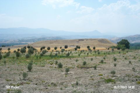 |
|
Type:
|
Mound |
|
Altitude:
|
300 m |
|
Region:
|
Mediterranean |
|
Province:
|
Mersin |
|
District:
|
Mut |
|
Village:
|
Kislaköy |
|
Investigation Method:
|
Excavation |
|
Period:
|
Ceramic |
|
|
|
 |
|
| Location: It lies 1 km south of the Kisla Village; about 36 km northwest of Silifke District; some 20.5 km southeast of Mut District; southwest of the Mersin Province. To the north runs the Silifke-Mut motorway. It is easy to access. |
| Geography and Environment: The mound which will be submerged together with Çingene Tepe nearby under the reservoir waters of the Kayraktepe Dam built 10 km away from Silifke on the Göksu River is also known as Maltepe (Mut). There is another settlement called Maltepe located south of Çingene Tepe on the opposite western bank of the river. It is locally known as Kilise Tepe and it was illustrated under this name in a 1:25.000 maps. It stands on a conglomeratic elevation with steep slopes and flat uphill overlooking the valley formed by the Göksu River. On the northern foot of this rocky block; there is a fresh water spring. Settlement is suggested to house a cultural deposit of ca. 20 m thick. A stream called Kurtsuyu passing by the western side joins the Göksu River down in the valley. |
| History: |
| Research and Excavation: It was introduced to the scientific world by J. Mellaart under the name of Maltepe accompanied with finds belonging to the Iron Age; the second and third millennia BC [Mellaart 1954:map.3]. The mound was reported under the name of Kilise Tepe by D.H. French who carried out a surface collection here in 1965. Although presence of Chalcolithic Age was indicated by J. Mellaart; such a level was not reached in the excavated areas. As the mound will be flooded by the Kayraktepe Dam; it has been excavated since 1994 in collaboration of the Silifke Archaeological Museum and the British Archaeological Institute under J.N. Postgate. Trenches opened on the uphill during the first years were followed by excavations aiming to verify the stratification on the northwestern part. Prehistoric layers were found at square H20. |
| Stratigraphy: The finds have been assigned to the Early Bronze Age; to the second millennium BC and skeptically to the Neolithic Periods. |
| Small Finds: Pottery: Mellaart notes that the ceramics were assigned to the Neolithic because both Dark Burnished Ware and Incised Decorated Ware closely resembling ceramics from the Neolithic layers at Mersin Yumuktepe were found [Mellaart 1958a:91]. French notes that his survey yielded ware with incised decoration [French 1965c:186]. Chipped Stone: Mellaart reports finding obsidian tools similar to those from the Neolithic layers at the sites of Ilicapinar (Konya) and Yumuktepe (Mersin). |
| Remains: |
| Interpretation and Dating: For a better understanding of the Neolithic at Maltepe; this site requires further research and surveying. In ASPRO; it has been assigned to the sixth phase. The uncalibrated dates for this site are 7;600-7;000 BP [Hours et al. 1994:231]. |