|
©The Archaeological Settlements of Turkey - TAY Project
|
|
|
|
|
|
Liman Tepe |
|
|
For site maps and drawings please click on the picture...  |
For photographs please click on the photo... 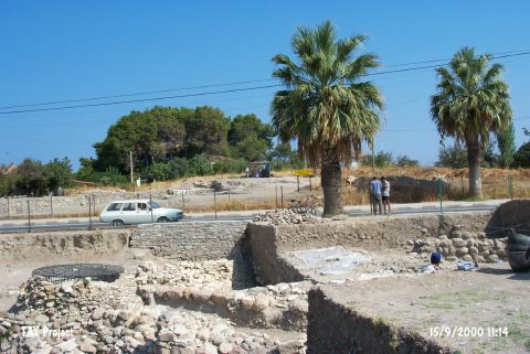 |
|
Type:
|
Mound |
|
Altitude:
|
0 m |
|
Region:
|
Aegean |
|
Province:
|
Izmir |
|
District:
|
Urla |
|
Village:
|
Merkez |
|
Investigation Method:
|
Excavation |
|
Period:
|
Late |
|
|
|
 |
|
| Location: It lies south of the Karantina Island; east of the modern harbor in the Iskele Quarter located north of the Urla District; west-southwest of the Izmir Province. It can be reached through the exit to the port of Urla from the Izmir-Urla highway which intersects the mound in the east-west direction by over passing it [Erkanal 1996:pic.6]. |
| Geography and Environment: The coastal plain on the north of Urla was; probably; formed by a long bay filled up later on. Firstly; the bay lost its contact with the sea due to a sand dune and then became an alluvial arose by the Zongurlu and Kocadere Streams. During this transformation; a group of natural rocks extending to the sea merged with the bedrock and ended up in a peninsula where Liman Tepe is located now. Due to the rocky block on the north; the peninsula is partly not open to the north winds. As the longitudinal ends of the rocky outcrop extending to the Gulf of Izmir serve like a natural port; and particularly the gulf has suitable conditions for sea trade; the site was occupied from the Late Neolithic Age. Fertile coastal plain on the south; probably; met all the food requirements of the inhabitants [Erkanal-Günel 1996:306]. As the ancient city of Clazomenai using the hill as acropolis which house the remains of the prehistoric settlements; was located on the southern part; it is clear that the site had been inhabited until the Roman Period. When it is noted that most of the ancient names derives from their prehistoric names; name of this site during the third millennium BC can be proposed as something similar to its ancient name. Liman Tepe has been partly destroyed by the summer houses on the coast and the neighboring territory. Excavation leader officially applied for moving the highway over passing the mound. |
| History: |
| Research and Excavation: Liman Tepe was first introduced as a prehistoric settlement by E. Akurgal [Akurgal 1950:4]. Excavations started at the ancient city of Clazomenai under G. Bakir and Ç. Anlagan in 1979. Later; excavations were extended to Liman Tepe considering the possibility that there can be an acropolis on the uphill. The 1980 and 1981 excavations yielded a monumental bastion/tower to the south of the highway as well as the significance of the settlement during EBA [Bakir-Anlagan 1981:88; Erkanal-Erkanal 1983:163-183; Bakir 1983:64-65]. Excavations covering only Liman Tepe have been continued since 1992 under H. Erkanal (See. References); and they are recently supported by the underwater excavations and geological researches conducted under the directorship of M. Artzy from the University of Haifa; Recanati Institute of Oceanography. The ancient city of Clazomenai has been explored since 1921-1922. |
| Stratigraphy: Some sherds recovered from the deposits of the late periods expose that the site had been first occupied during the Late Neolithic Age. Level belonging to the Middle Chalcolithic Age was uncovered in the trench to north of the highway. Heyday of the settlement was between EBA I and II. Trenches opened to the north of the highway yielded four building levels of EBA II and two building levels of EBA I while the southern trenches yielded only two building levels for now. It is noted that the MBA and LBA settlements are bigger compared to the EBA settlements. MBA houses 5 building levels and LBA only 1 level which were partly obscured by the buildings of the ancient Clazomenai of the Hellenistic and Roman Periods. The ancient city was expanded to the south. Exposure of a lesser degree of destruction on the uphill and presence of only one or two cisterns and well were concluded that this part was not heavily occupied during the late periods. |
| Small Finds: Architecture: The Late Chalcolithic levels (LMT VII) were exposed only the northern half of the excavation area. The burnt level yielded a partially preserved hearth and an oven floor. The oven floor was paved with broken pottery sherds and plastered with clay. Slag fragments, stone cupels and stones for mineral enrichment were found in the area. In 2014, the southern extension of the burnt house expsed during 2004-2005 seasons was recovered. One of the important results of the excavation season is two grilled planned structures exposed in the west and east eadges of the excavation area. The floors of both structures are about 5 cm thick and plastered with clay. It is found out that the structure in the west has mud brick walls with a thickness of 20 cm. The similar structures are known from Bakla Tepe located in the vicinity. The fact that the structures were built smaller stones (in comparison to the ones in Bakla Tepe) and lack of stone foundations of the long mud brick walls suggests that these structures might have been used for special purposes (storage?) [Erkanal et al. 2016: 331-332]. Pottery: Among the finds exposed in this burnt level, a partially preserved (however it is possible to complete it), white-washed, black burnished jar with a thin paste is noteworthy. The rim edge was decorated with upside down triangles (centers of which adorn with horizontal lines) and ram heads were placed on top of the rim. The fact that a black burnished juglet was found immediately next to this jar suggests that all of these wares were used for ritualistic purposes. |
| Remains: |
| Interpretation and Dating: |