|
©The Archaeological Settlements of Turkey - TAY Project
|
|
|
|
|
|
Küllünün Ini |
|
|
For site maps and drawings please click on the picture...  |
For photographs please click on the photo... 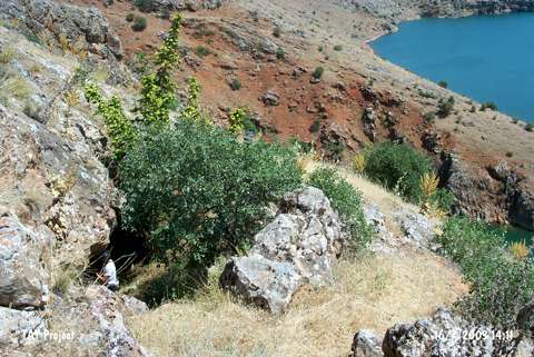 |
|
Type:
|
Rock Shelter |
|
Altitude:
|
880 m |
|
Region:
|
Eastern Anatolia |
|
Province:
|
Elazig |
|
District:
|
Agin |
|
Village:
|
Yeniyapan |
|
Investigation Method:
|
Excavation |
|
Period:
|
|
|
|
|
 |
|
| It is located at Gedikler Mevkii; close to Hastek Village; northwest of Elazig Province. The rock shelter was discovered by K. Kökten in 1969. It was tested by soundings in 1970-1972. The bedrock was reached at 3-3.5 m. It is claimed that the cultural deposit is damp and pressurized. The bedrocks fell down as a result of earthquakes. A trench opened near the entrance yielded two levels covering pottery in 2 m depth [Kökten 1974:1]. Remains of a kiln were uncovered [Kökten 1972:1]. No information is provided about the pottery and other finds. |
| Location: The cave site is northwest of the city of Elazig; 5 km west of the town of Agin; close to the village of Yenipayam which used to be called Hastek; in the neighborhood of Gedikler along the Arapkir Stream. |
| Geography and Environment: It is located on a slope near dam reservoir and its moth faces south. The name of the rock shelter is probably local. |
| History: |
| Research and Excavation: |
| Stratigraphy: |
| Small Finds: |
| Remains: |
| Interpretation and Dating: |