|
©The Archaeological Settlements of Turkey - TAY Project
|
|
|
|
|
|
Kilise Tepe / Maltepe |
|
|
For site maps and drawings please click on the picture... 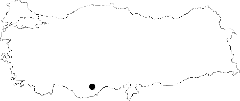 |
For photographs please click on the photo... 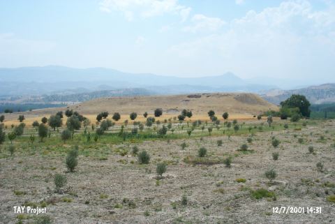 |
|
Type:
|
Mound |
|
Altitude:
|
300 m |
|
Region:
|
Mediterranean |
|
Province:
|
Mersin |
|
District:
|
Mut |
|
Village:
|
Kislaköy |
|
Investigation Method:
|
Excavation |
|
Period:
|
EBA III |
|
|
|
 |
|
| Location: It lies 1 km south of the Kisla Village; about 36 km northwest of Silifke District; some 20.5 km southeast of Mut District; southwest of the Mersin Province. To the north runs the Silifke-Mut motorway. It is easy to access. |
| Geography and Environment: The mound which will be submerged together with Çingene Tepe nearby under the reservoir waters of the Kayraktepe Dam built 10 km away from Silifke on the Göksu River is also known as Maltepe (Mut). There is another settlement called Maltepe located south of Çingene Tepe on the opposite western bank of the river. It is locally known as Kilise Tepe and it was illustrated under this name in a 1:25.000 maps. It stands on a conglomeratic elevation with steep slopes and flat uphill overlooking the valley formed by the Göksu River. On the northern foot of this rocky block; there is a fresh water spring. Settlement is suggested to house a cultural deposit of ca. 20 m thick. A stream called Kurtsuyu passing by the western side joins the Göksu River down in the valley. |
| History: |
| Research and Excavation: It was introduced to the scientific world by J. Mellaart under the name of Maltepe accompanied with finds belonging to the Iron Age; the second and third millennia BC [Mellaart 1954:map.3]. The mound was reported under the name of Kilise Tepe by D.H. French who carried out a surface collection here in 1965. Although presence of Chalcolithic Age was indicated by J. Mellaart; such a level was not reached in the excavated areas. As the mound will be flooded by the Kayraktepe Dam; it has been excavated since 1994 in collaboration of the Silifke Archaeological Museum and the British Archaeological Institute under J.N. Postgate. Trenches opened on the uphill during the first years were followed by excavations aiming to verify the stratification on the northwestern part. Prehistoric layers were found at square H20. |
| Stratigraphy: It was revealed that the site houses settlements of Byzantine Period; Late Roman Period; Iron Age; MBA and EBA respectively. A systematic survey conducted on the surface of the mound yielded sherds largely dating to EBA on the southern slope. And a very small area of trench H20 on the northwest yielded settlement of this period at building levels coded as e; f; g; h; i; j and k. |
| Small Finds: Architecture: (descending order) Remains of walls uncovered in the building levels e-i dating to EBA did not provide a complete plan. Structure found in the building level-g underwent a fire which resulted in the hardening of plasters on the mudbrick walls. A round hole in the lower part of a gateway uncovered is the sign of a wooden door. Presence of a round cavity plastered around exposes that the doorposts are also wooden. No traces of fire were observed in this level. Building level i yielded a small round stone foundation whereas building level j has architectural remains in better conditions than the other levels [Jackson-Postgate 1999:fig.8]. It has in situ finds as it underwent a massive fire. Floor of this building was reached at 11.5 m depth from the top of the hill [Postgate 1998:218]. Having a deposit of ca.1 m thick; it yielded three structures of which the mudbrick walls were plastered elaborately. No information is provided about the stone foundation. Places for hearths and low clay platforms present an idea about the way of daily life. A small room on the west houses a big jug including a small service cup on its floor [Jackson-Postgate 1999:fig.8]. On the southern part of this room; the floor is damaged. Other rooms are full of samples representing the pottery industry. Also found is a horned stand in terra cotta. A stone foundation was uncovered at building level k standing right over the conglomerate and introduced as the first settlement of the mound. In 2007, a team from Selçuk University at Konya worked in squares G19 and G20 on the northwest edge of the mound. The destruction level observed previously in Level Vg (end of EB II) was found to extend westwards and several floors with pottery vessels in situ were uncovered [http://cat.une.edu.au/page/kilise%20tepe; 10.11.2009; 17:05]. The main goal of the 2010 excavation campaign was to prepare the final report of the conclusions of the studies conducted between 2007 and 2009. 4 building phases have been discovered during the studies. Among these phases, the richest finds were recovered from Phase 4 which is the earliest one. Phase 4 is rich in pottery and almost all the in situ EBA finds were recovered from the ashy demolishment layer on the north of the wall 8002. The only architectural remain belonging to Phase 3 is the wall 8001. Because of the wall 8001, the demolishment layer of this phase could be traced in whole trench, except Square G19a. The only architectural remain belonging to Phase 2, which is on top of Phase 3, is the wall 8000 and it extends in the northwest-southeast direction [Serifoglu 2012:376-377]. The 2011 campaign show that Room 68 belongs to Level Vg which is the earliest occupation of EBA. In the northeast section of Room 68, The wall labelled W800, which was entirely built with medium-sized river stones, is located. This wall measures 6 m in length and 1.5 m in height and extends into G20d. The small room, labelled Room 69, is located to the east of the wall. The wall W8005 that was built with medium-sized stones extends towards its southeast. Like Room 68 and H20 where the remains belonging to Vg were exposed, this room was filled with debris composed of pieces of mudbricks and wall plaster. Although the northeast wall of the room has been damaged by the illicit digging pit in H20, the bottom section of its mudbrick wall, the southeast face of which was plastered, was preserved. The fact that the walls numbered W8001 and 8005 were built in stone masonry with a height of 1.5 m indicates that these walls were not ordinary walls. Located to the slopes of the mound, these walls could have been built in order to reinforce or defend the structure. Room 69 is a later addition. A hearth was exposed close to the west wall of Room 69. To the north of its west wall, a small pit was found. The impression of a storage vessel was encountered on its south corner. After the destruction of the Vg building the remains exposed in this area was covered by a light brown plaster surface and then it was used as an open area. This earlies Vf phase yielded an oven (?) with a diameter of 2 m built on the southwest corner of Vg room. Not long after the area started to be used again, a building was built in the south of the oven [Jackson et al. 2013]. Pottery: A deep sounding at H20c yielded a red-cross decorated flat bowl at building level e; dating to EBA III [Postgate 1997:fig.7; Postgate 1998:218]. Such decorated vessels are common at the end of EBA in Anatolia. Handmade and very well burnished pottery was recovered from the building level h and lower two levels; and they were dated to EBA by the leader of the excavation team. The building level h yielded a red washed small cup [Postgate 1998:fig.10] which was incision decorated with filled in triangles. Likes of this cup in style and decoration are seen at Gözlükule of Tarsus. The building level j yielded juglets decorated with red painting before undergoing a fire. Intersecting lines were preferred as decorations. The building level j is the level we can best comprehend the industry of this period with its in situ finds. An interesting find is a goblet-like cup [Jackson-Postgate 1999:fig.10]. The wares of Phase 4 bear the characteristics of EBA II and the majority of them are bright red and black burnished, light grey colored wares with soft pastes. Apart from these, there are a few potsherds, which were hatched in different directions, belonging to scored ware group. In the level which consists the end of Phase 3 and the beginning of Phase 2, it has been observed that EBA II and EBA I wares were mixed. The majority of EBA III wares with orange pastes are hardly fired, plain or red / brown slipped. One deep bowl with red colored cross decoration and an S profiled and slightly carinated deep bowl are among the important finds recovered from this phase. EBA III pottery tradition became dominant at the end of Phase 2. In this phase, shallow bowls with orange paste and inverted rim and red slipped wares with parallel notch decorated handles, plain large pithoi or large pithoi with everted rim were found [Serifoglu 2012:378]. During the 2011 excavation studies, a complete double spouted jug and a complete single handled cup with flaring rim were found in situ on the floor in Vf phase. In addition, a half complete red cross bowls was found. A clay storage vessel, about 70 cm in diameter, was built to the north of W8000 [Jackson et al. 2013:6]. Small Finds: Stepped squares on the northwest opened in order to go down to EBA levels yielded spindle whorls in clay; two baton-heads in stone; one in white and the other in black. Among the finds, there are also spindle whorls. Although the biconical spindle whorls with impressed decoration were dominant in Phase 4, in Phase 3 the ones with linear geometric decoration were also seen. In phase 2, impressed decoration was left and incised motifs werepreferred. Besides biconical spindle whorls, hemispherical and conical spindle whorls were also produced. At the end of EBA, in Phase 1, decorations became more simple and even spindle whorls with no decoration were produced. A red painted, octagonal, star shaped spindle whorl is an exceptional example found in this phase [Serifoglu 2012:378-379]. Metal: A copper earring was found in Level Vf [Jackson et al. 2013:6]. |
| Remains: |
| Interpretation and Dating: Named after the remains of a church standing on it; Kilise (Church) Tepe is located on one of the two roads connecting the Mediterranean shore to Central Anatolia through the Konya Plain [Baker et al. 1995: 142-143; maps at fig.1 and 2]. It is situated in a natural alley formed by the Göksu River and it is one of the most significant settlements in size. The published results of the excavations do not allow us to comprehend the culture in detail. However; it can be proposed that the site functioned as a bridge between EBA cultures of the Central Anatolia and Mediterranean Regions. Exact dating of the building levels has been postponed; and the results of 14C are not provided yet; but similar finds expose the presence of EBA II and III. Similar published EBA vessels are also found at Cyprus. |