|
©The Archaeological Settlements of Turkey - TAY Project
|
|
|
|
|
|
Kayi Köyü Höyügü |
|
|
For site maps and drawings please click on the picture...  |
For photographs please click on the photo... 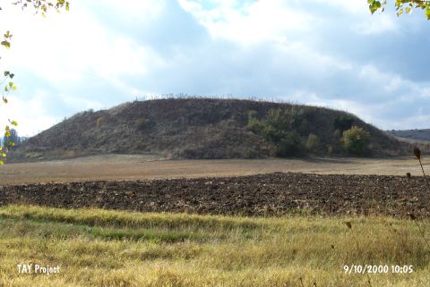 |
|
Type:
|
Mound |
|
Altitude:
|
930 m |
|
Region:
|
Aegean |
|
Province:
|
Kütahya |
|
District:
|
Tavsanli |
|
Village:
|
Kayi |
|
Investigation Method:
|
Survey |
|
Period:
|
EBA III EBA II |
|
|
|
 |
|
| It is located behind the poplar grove 3.1 km from the entrance of Kayi Village; 6 km west of Tavsanli; northwest of Kütahya Province. To its south flows a stream. The materials collected from the surface were evaluated by T. Özgüç. According to T. Özgüç; the oldest find among those materials is the exteriorly and interiorly black washed ware. It is dated to the midst of the third millennium BC. The finds with red washed ware resemble the transition ware from Kusura B to C. Also found is gray colored ware. It is suggested that the site had been inhabited from the third millennium BC onwards [Özgüç 1946:566]. It takes place in the registered archaeological sites list prepared by Ministry of Culture and Tourism. |
| Location: |
| Geography and Environment: |
| History: |
| Research and Excavation: |
| Stratigraphy: |
| Small Finds: |
| Remains: |
| Interpretation and Dating: |