|
©The Archaeological Settlements of Turkey - TAY Project
|
|
|
|
|
|
Altintepe |
|
|
For site maps and drawings please click on the picture...  |
For photographs please click on the photo... 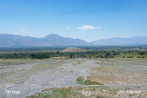 |
|
Type:
|
Mound |
|
Altitude:
|
1290 m |
|
Region:
|
Eastern Anatolia |
|
Province:
|
Erzincan |
|
District:
|
Üzümlü |
|
Village:
|
Merkez |
|
Investigation Method:
|
Excavation |
|
Period:
|
EBA II |
|
|
|
 |
|
| It partly stands on a natural rock on the road running from Erzincan to Erzurum; 20 km east of Erzincan Province. It is 1.2 km from the Erzurum-Erzincan motorway. It measures 60 m in height and 200 m in diameter. Finds dating from the Urartu Period attracted the attention to this mound. It was excavated by a team under T. Özgüc in 1959. The excavations targeting the Urartu Period yielded a single-layer EBA settlement which underwent a fire. Vast majority of the pottery includes the black/brown washed ware with burnished exterior and interior surfaces. The red washed ware is very rare. They are decorated with incision and grooves as well as decorated in parallel and zigzag motifs. It is suggested that those wares slightly differing from the Karaz ware are local; and older than Karaz. It takes place in the registered archaeological sites list prepared by Ministry of Culture and Tourism. |
| Location: It lies to the immediate north of the Erzurum-Erzincan motorway, 20 km east of Erzincan. |
| Geography and Environment: Lying on the northern edge of the very fertile Erzincan Plain, Altintepe also commands the renown trade road running from East Anatolia to Central Anatolia. The oval-planned hill on which the fortress of Altintepe rises is 60 m high above the plain. It is 1290 m high. |
| History: |
| Research and Excavation: |
| Stratigraphy: |
| Small Finds: |
| Remains: |
| Interpretation and Dating: |