|
©The Archaeological Settlements of Turkey - TAY Project
|
|
|
|
|
|
Karapinar Mevkii |
|
|
For site maps and drawings please click on the picture...  |
For photographs please click on the photo... 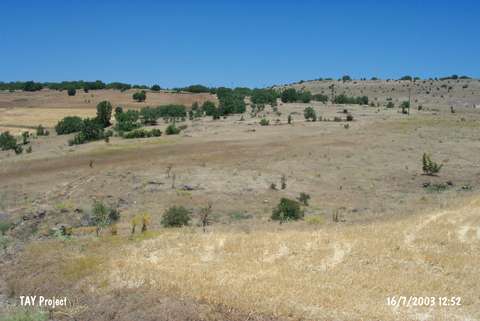 |
|
Type:
|
Habitation Site / Workshop |
|
Altitude:
|
1040 m |
|
Region:
|
Eastern Anatolia |
|
Province:
|
Elazig |
|
District:
|
Agin |
|
Village:
|
Samançay |
|
Investigation Method:
|
Survey |
|
Period:
|
AP OP |
|
|
|
 |
|
| Location: This site is near the Armutlu quarter of Samançay village; 7 km northwest of the town of Agin; northwest of the city of Elazig. The site is located in Karapinar Mevkii; 1 km south-southeast of the village and close to the dam reservoir. |
| Geography and Environment: The presumed lush vegetation and abundant water sources may have been among the reasons for Palaeolithic habitation in this region. The high number of nearby rock-shelters and flint outcrops were probably additional attractions of this site. |
| History: |
| Research and Excavation: This Karapinar Plain site discovered by Kiliç Kökten in 1969 is one of the many Palaeolithic workshops he discovered during his 1969 and 1972 surveys of the regions expected to be flooded by the Keban Dam Lake. The fact that this site was an atelier may also indicate that habitation here was temporary. |
| Stratigraphy: |
| Small Finds: Kökten's discovery of crested and biface cleavers he assigns as Préchellén is especially interesting and important both because they are rare in Anatolia and because they are thought to be prototypes for real handaxes. The large flake tools which are technologically one step behind classic handaxes are crested with a naviform-shaped distal end [Kökten 1971b:fig;14]. We can classify the tools from this site as Acheuléen and Levalloiso-Mousterién and date them to the Lower and Middle Palaeolithic Periods. These tools include Chelléen (or Abbevillien)-Acheuléen handaxes; large scrapers with wide sides; older Levallois type large point and scrapers; with Moustérien characteristics. |
| Remains: |
| Interpretation and Dating: |