|
©The Archaeological Settlements of Turkey - TAY Project
|
|
|
|
|
|
Karahöyük |
|
|
For site maps and drawings please click on the picture...  |
For photographs please click on the photo... 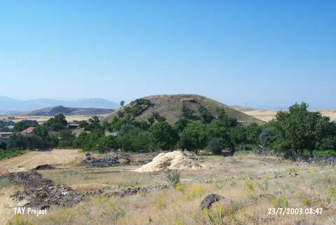 |
|
Type:
|
Mound |
|
Altitude:
|
1150 m |
|
Region:
|
Eastern Anatolia |
|
Province:
|
Malatya |
|
District:
|
Arguvan |
|
Village:
|
Karahöyük |
|
Investigation Method:
|
Survey |
|
Period:
|
EBA II EBA III |
|
|
|
 |
|
| It lies west of Karahöyük Village; 6 km northeast of Arguvan District; north of Malatya Province. It measures 20 m in height and 125 m in diameter. It was discovered by C.A. Burney in 1956. Samples of ware with exteriorly and interiorly different colored surfaces; Karaz/Early Transcaucasian ware; red-brown burnished ware and EBA II -III painted ware were collected from the surface. It takes place in the registered archaeological sites list prepared by Ministry of Culture and Tourism. |
| Location: |
| Geography and Environment: |
| History: |
| Research and Excavation: |
| Stratigraphy: |
| Small Finds: |
| Remains: |
| Interpretation and Dating: |