|
©The Archaeological Settlements of Turkey - TAY Project
|
|
|
|
|
|
Inbogazi Magaralari |
|
|
For site maps and drawings please click on the picture...  |
For photographs please click on the photo... 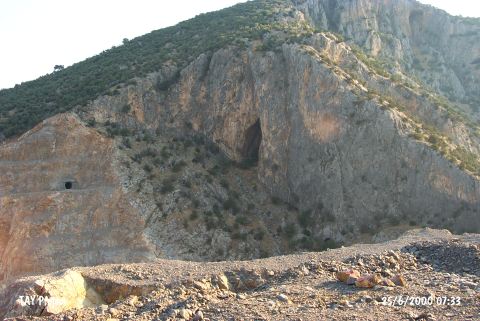 |
|
Type:
|
Cave |
|
Altitude:
|
120 m |
|
Region:
|
Marmara |
|
Province:
|
Balikesir |
|
District:
|
Havran |
|
Village:
|
Inönü |
|
Investigation Method:
|
Excavation |
|
Period:
|
Late |
|
|
|
 |
|
| The site; a cave formation with 7 mouths; lies west of Balikesir; 1.5 km southeast of Inönü village; in Inbogazi Mevkii of Çal Mountain. It was discovered by Kökten in 1949. Some of the names of the caves are Devedane; Karanlik; Aydinlik and Ardik. An excavation was conducted by Kökten at the largest one; Karanlik. Black and brown burnished; incised decorated sherds; dating to the Neolithic Age and Chalcolithic Age; were found at the 3rd level. The site was revisited by M. Özdogan in 1987. Chalcolithic Age; EBA and Medieval Age settlements are mentioned. The location code of the site is K 5 / 3. |
| Location: It is located 1500 m behind the village of Inönü; 6 km east of the Havran District; west of the Balikesir Province. |
| Geography and Environment: In the vicinity of Inbogazi Mevkii; aside Karanlik Magara; there are several caves like Devedami; Aydinlik and Andik. Introduced as Inbogazi Caves; those caves stand on the calcareous slope of the Büyük Çal mountain facing the Gelinderesi stream. Among them; only Karanlik Magara was investigated and provided information about the local culture. Therefore; the finds should have been presented under the name of the Karanlik Magara. The construction of the Havran Dam is in progress. The caves will be partly influenced by the dam. |
| History: |
| Research and Excavation: |
| Stratigraphy: |
| Small Finds: |
| Remains: |
| Interpretation and Dating: |