|
©The Archaeological Settlements of Turkey - TAY Project
|
|
|
|
|
|
Hassanlar |
|
|
For site maps and drawings please click on the picture...  |
For photographs please click on the photo... 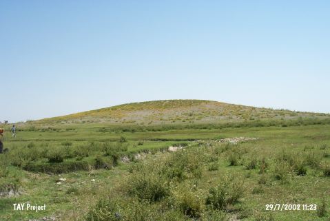 |
|
Type:
|
Mound |
|
Altitude:
|
1095 m |
|
Region:
|
Central Anatolia |
|
Province:
|
Nevsehir |
|
District:
|
Hacibektas |
|
Village:
|
Hasanlar |
|
Investigation Method:
|
Survey |
|
Period:
|
|
|
|
|
 |
|
| It is located in the southeast exit of Hasanlar Village in Hacibektas District of Nevsehir Province. It was discovered during the survey conducted by A. Türker in 2013. Türker stated that the mound measures 255 m in diameter and 10 m in height. EBA, MBA and Late Roman-Byzantine wares were collected from the surface. A cist grave was determined in the west of the mound [Türker 2015:235]. |
| Location: This site lies at Harim/Köybolugu Mevkii; very close to the village of Hasanlar; north of Nevsehir Province. It is on the Nevsehir-Kirsehir city border. |
| Geography and Environment: Although the dimensions of the mound have not been provided; from the photo in the publication it is clear that the mound is middle-sized and broad mound. In Omura's publication; the site is referred to as Hassanlar; although in the map; the name of the village appears to be Hasanlar (Avanos 1:200;000). The site name chosen here is the name given by the survey director. The mound lies in the flat area known as Çerçiçölü; where Lake Seyfe is located. The inhabitants of this site could have used Kolaycik Stream as their water supply. Nearby; there is another small seasonal stream. The swamps near the mound may have functioned as hunting grounds for the inhabitants of the site. |
| History: |
| Research and Excavation: |
| Stratigraphy: |
| Small Finds: |
| Remains: |
| Interpretation and Dating: |