|
©The Archaeological Settlements of Turkey - TAY Project
|
|
|
|
|
|
Hesigin / Tülek |
|
|
For site maps and drawings please click on the picture...  |
For photographs please click on the photo... 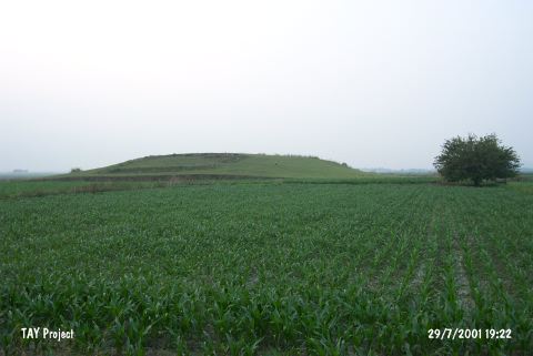 |
|
Type:
|
Mound |
|
Altitude:
|
100 m |
|
Region:
|
Mediterranean |
|
Province:
|
Adana |
|
District:
|
Ceyhan |
|
Village:
|
Kurtkulagi |
|
Investigation Method:
|
Survey |
|
Period:
|
Late |
|
|
|
 |
|
| The 15 m high mound lies 6.6 km north of Kurtkulagi (Kurtkuluk) Village; southeast of Ceyhan District; east-southeast of Adana Province. The real name of the mound is Tülek Höyük. It was discovered by M.V. Seton-Williams in 1951 and revisited during the survey around Çukurova conducted by the University of Bilkent in 1991. There are terraces at the top; and the mound is extremely damaged. Irrigation ducts surround the hill in the present. Continuous settlements from the EBA to Roman Period are existent at the mound. In addition; sherds of smoothed-surfaced; light slipped ware; resembling the sherds of Amuq F phase; dating to the Late Chalcolithic Age; were found. It takes place in the registered archaeological sites list prepared by Ministry of Culture and Tourism. |
| Location: |
| Geography and Environment: |
| History: |
| Research and Excavation: |
| Stratigraphy: |
| Small Finds: |
| Remains: |
| Interpretation and Dating: |