|
©The Archaeological Settlements of Turkey - TAY Project
|
|
|
|
|
|
Gritille |
|
|
For site maps and drawings please click on the picture... 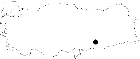 |
For photographs please click on the photo...  |
|
Type:
|
Mound |
|
Altitude:
|
426 m |
|
Region:
|
Southeastern Anatolia |
|
Province:
|
Adiyaman |
|
District:
|
Samsat |
|
Village:
|
Halilan |
|
Investigation Method:
|
Excavation |
|
Period:
|
Ceramic Aceramic |
|
|
|
 |
|
| Location: Before it was flooded by the Atatürk Dam Lake; the site was located southeast of the city of Adiyaman; 7 km northeast of the old town of Samsat and 3 km northeast of the old neighborhood of Kovanoluk (Biriman). The survey code of the site is T 51 / 9. |
| Geography and Environment: The site of Gritille was located on the western shore of the old Euphrates River; which flowed from northeast to southwest; before the Atatürk Dam was built. The conical; oval mound; now beneath the dam lake; had a 13 m thick cultural material deposit and was 80x40 m at the top and 150x100 m at the base. The mound; also known as Tille; lies on conglomerate and gravely soil along the Euphrates River. The upper part of the mound lay 24 m above the water-level of the Euphrates River before the construction of the Atatürk Dam Lake [Ellis 1983a:83]. The exact size of the mound cannot be determined because the eastern part of the mound was eroded by the Euphrates. The mound; therefore; became oval in shape and lay along the river; parallel to it. Systematic survey conducted on and around the mound revealed that the most extensive occupation of the site was in the thirteenth century AD. The fact that the mound overlooks a flat plain along the Euphrates and the fact that there are two springs on the eastern side of the mound were probably major factors in its selection as a habitation area. The islands formed on the base of the Euphrates River Valley are attractive places for grazing in the summers when the surrounding pastures are dry. The trees that grow along the Euphrates River may have also supplied the inhabitants of Gritille with adequate wood. Good quality flint for producing chipped stone tools may be obtained from the ridges a couple of kilometers west of the mound. The Gritille Region is thus highly equipped with many necessities. |
| History: |
| Research and Excavation: The site was discovered in 1975 by a survey team led by Ü. Serdaroglu [Serdaroglu 1977:117; fig.9; 64 maps]. Because the site was in the region expected to be flooded by the Atatürk Dam Lake; the area was resurveyed in 1977 by M. Özdogan of the University of Istanbul; Faculty of Letters; Department of Prehistory during the Lower Euphrates Basin Project. Excavations at the site were conducted from 1981 to 1984 with the financial support of Bryn Mawr College and North Carolina University under the direction of R.S. Ellis and M.M. Voigt. Voigt worked especially on the Neolithic layers. While the first two years of excavation were devoted to determine the general stratigraphy of the site; the Neolithic and Medieval layers were researched in detail in the last two seasons. The steep east-southeastern side of the mound was selected for the excavation of the Neolithic layers at the site. Because the mound was so steep; excavators resorted to north-south step trenching. Different excavation strategies were used in accordance with the architectural remains. |
| Stratigraphy: Much of an old Crusader Castle was exposed in the upper most part of the mound. Early Bronze Age layers lay beneath the castle while Neolithic Layers began nine meters beneath the mound surface; immediately beneath Early Bronze. A total of five Neolithic layers were noticed in the four meters between the Early Bronze Layers and virgin soil. The upper four levels have been labeled A; B; C and D consecutively while the fifth layer beneath them has been called the bottom-most/lowest layer. |
| Small Finds: Architecture: Because excavations did not concentrate on the center part of the mound; architectural remains were scarce. Occupational phases; where architectural remains were found; began in Level B. Level A: Because there was no habitation at the mound from the Neolithic to the Early Bronze Age; much of the architectural structures from the occupational phases of the former were eroded and the remaining foundations were cut by Early Bronze Age trash pits. This uppermost level of Neolithic habitation at the site yielded pebble walkways. Level B: In this layer 3 adjacent structures made with red mudbrick were exposed. The mudbrick walls of all three structures; which were labeled 1; 2 and 3; were built on stone foundations. It has been noticed that Building 2 was divided into smaller rooms by thinner; interior mudbrick walls. Building 1 is adjacent to this structure. On the other side of Building 2 was an open courtyard area. North of the courtyard; the corner of a very thick walled mudbrick structure; Building 3; was exposed [Ellis 1986: plan in fig. 3]. Some aligned mudbricks in Building 3 suggest that the building had interior dividing walls similar to Building 2. The floors of all the buildings are compacted soil surfaces. Several pestles; flat axes and points were found on the floor of Building 2. Although no hearths were found in either Building 2 or 3; the stone lined cooking pit in Building 2 suggests that both structures were used for habitation. Building 1; on the other hand; which yielded many animal bones and seeds mixed together with clay suggests that this area was an open-air enclosure. Such enclosures could probably be found in other levels as well. It is difficult to construct a village plan from such a small sample of structures. Level C: Excavation in Level C yielded a thick-walled mudbrick building; which is 2.5-3x2 m in size. Some cylindrical food storage pits were found among some eroded structural elements. The walls and floors appear to have been plastered with white plaster. Level D: This level; exposed in a very limited area of the stepped trench; yielded a stone paved area. Because the exposed area was small; the function of the paving could not be determined. White clay and plaster fragments were also found in this level. The Bottommost/Lowest Level: This level; where the oldest Neolithic material was found; is least 50 cm thick and lies above virgin soil. Pottery: With the exception of Level A; and the latest occupational phases of Level B none of the Neolithic levels yielded pottery. The pottery found is a type of dark gray ware with fine tempering and with gray cores. Clay Finds: Baked clay human and animal figurines which are dark brown or black in color were found in several different Neolithic levels. Ram and cattle figurines have also been recovered. Sun-dried; unbaked clay gaming pieces; some cylindrical clay objects which may have functioned as stamps (?) were also found. Another important clay find is a large human-foot-shaped object found by a plastered wall in Level C. Chipped Stone: The examples of chipped stone tools found at this site resemble those found at other pre-Pottery Neolithic sites in the region. The most commonly used raw material is flint. Ground Stone: Some spherical flint and chalkstone objects; slightly concave grinding stones with flat bottoms as well as smaller millstones and other tools to grind wheat and barley were found. Pestles; polished celts; bowls; some burnished; carved from stone with garnet inclusions; chalkstone; marble and limestone were found. Excavation also yielded a few soft limestone and chalk human figurine fragments. Beads in a variety of different shapes and styles were found. Some of the beads such as two discoid turquoise beads and a carnelian pendant; which had been made from non-local stones suggest that trade may have been going on between the Neolithic peoples of Gritille and other contemporaneous sites. Bone/Antler: Bone awls; needles; amulets and scrapers were found. Among the bone needles; the most common type is the long thin one with single piercings and a circular cross-sections. Human Remains: The physical characteristics of the Neolithic peoples of Gritille and information on their health problems could not be analyzed in detail because very few burials were found. Excavation yielded the very badly preserved skeleton of a young boy buried in a circular pit grave dug into virgin soil. Another burial was found within the habitation area. This sample size is much too small to make any claims about the burial practices of these Neolithic peoples. Fauna: Analysis of the animal remains found during the excavation has not yet been completed. The preliminary studies showed that sheep; goat; cattle and maybe even pig was domesticated. The morphological study of the bones confirms that this transition did occur. This process appears to have been done primarily for the use of their meat although use of additional benefits such as their milk and wool was resorted to. It has been suggested that the domesticated animals of Gritille were the main source of protein during the spring; summer and fall but that they depended on hunt-animals in the winter. The analysis of the bones and the comparison of the percentages clearly show that sheep and goat are the largest source of meat in this Neolithic village. 80% of the total bones belong to these two animals. Sheep appears to be more common than goat while both cattle and pig are much less common. Hunting also appears to have been commonly practiced. Wild sheep; wild goat; wild cattle and deer; gazelle; hare and porcupine were hunted. Dog must also have been domesticated. Stein further mentions that the inhabitants of this site close to the Euphrates subsisted on fresh water mussels and fish [Stein 1986a:42]. Flora: Domesticated Emmer wheat and lentils were found in the upper Neolithic Levels. Two row barley and other wild cereals are less common. Other: The lowest Neolithic levels yielded some bowls; pendants and small spherical objects made of plaster. A "white-vessel" plaster vessel was also found. |
| Remains: |
| Interpretation and Dating: The excavation of the Neolithic levels at Gritille Höyük could only be conducted in the steeper part of the mound. Although the entire settlement pattern of the village and other general trends could not be discerned; the excavation of this site; along with the sites of Hayaz and Nevali Çori; did enlighten our knowledge of the Aceramic Neolithic in this region. The excavation directors assign the Neolithic finds to the pre-Pottery Neolithic B (PPNB). 14C dating results for charcoal samples from various levels are: Level B; uncalibrated: 6;050±150 B.C - 6;150±80 BC Level C; uncalibrated: 6;290±240 B.C - 6;920±90 BC Bottommost/lowest Level; uncalibrated: 6;760±190 BC. |