|
©The Archaeological Settlements of Turkey - TAY Project
|
|
|
|
|
|
Girnator |
|
|
For site maps and drawings please click on the picture...  |
For photographs please click on the photo... 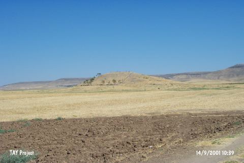 |
|
Type:
|
Mound |
|
Altitude:
|
700 m |
|
Region:
|
Southeastern Anatolia |
|
Province:
|
Batman |
|
District:
|
Besiri |
|
Village:
|
Binatli |
|
Investigation Method:
|
Survey |
|
Period:
|
|
|
|
|
 |
|
| It stands on Sirrika Tepet; 3.5 km northeast of Binatli (Bileyder/Tilmis) Village; 8.5 km east of Batman Province. It is a small mound. It measures 15 m in height and 75 m in diameter. There is no fresh water spring nearby. To the east flows the Sirrika Stream. It was discovered during a survey aiming to locate the settlements of the Food Producing Stage conducted in Siirt and Diyarbakir in 1963. Presence of EBA pottery was reported. It is coded under S 61 / 1. |
| Location: |
| Geography and Environment: |
| History: |
| Research and Excavation: |
| Stratigraphy: |
| Small Finds: |
| Remains: |
| Interpretation and Dating: |