|
©The Archaeological Settlements of Turkey - TAY Project
|
|
|
|
|
|
Girharrin / Gülharrin |
|
|
For site maps and drawings please click on the picture...  |
For photographs please click on the photo... 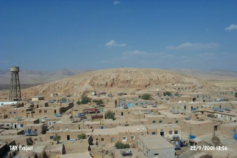 |
|
Type:
|
Mound |
|
Altitude:
|
450 m |
|
Region:
|
Southeastern Anatolia |
|
Province:
|
Mardin |
|
District:
|
Yesilli |
|
Village:
|
Ortaköy |
|
Investigation Method:
|
Survey |
|
Period:
|
EBA III EBA II |
|
|
|
 |
|
| Location: It lies in the center of the village of Ortaköy (Girharrin) Village located immediate west of the Mardin-Nusaybin motorway; 11 km south-southeast of the Mardin Province [Ay 1995:map at 27]. |
| Geography and Environment: It measures 40 m in height above the plain level and 400x300 m in dimensions including the terraces. The cone of the mound measures 75x70 m. It has an oval shape. It is located on the western bank of the Rijli Stream. The valley of Navala Kutte; where the mound is located at the entry; provides a natural alley to the northeast. It is close to the road called King's Road. The mound has been severely destroyed by the local villagers and treasure hunters. The name is suggested to derive from Gir (hill) and Harrin (road). It is claimed that the city of Huzirina mentioned in the Assyrian documents is located here. |
| History: |
| Research and Excavation: A systematic and intense survey was conducted in 1988-89 upon the declaration of the site by the Museum of Mardin to the excavation team at Girnavaz Höyügü. The material collected was analyzed by Eyüp Ay [Ay 1993]. It takes place in the registered archaeological sites list prepared by Ministry of Culture and Tourism. |
| Stratigraphy: The materials of the first-third millennia BC expose the presence of settlements during these periods. Pottery of the Halaf and Late Uruk Periods was also found. Limited number of pottery belonging to the Islamic Period sheds light on the late period settlements. |
| Small Finds: Pottery: Plenty of samples belonging to the metallic ware and the Nineveh V ware were collected from the surface. The metallic ware is of wheel-made. The potters had given an impression of natural decoration on these thin pasted vessels by leaving the traces of the wheel on by intent. The samples of this ware are represented by a percentage of 18% at Gil Harrin. There are sub-groups of the ware such as ground thin basalt tempered; mica tempered; thin-strained small grit tempered; grit and straw tempered ware. Except a piece of grayish green mottled ware; all the vessels are unwashed and plain. Forms of beakers; bowls and jars as well as pedestals are common [Ay 1995:fig.I/10-III/13]. The metallic cups were also recovered from the settlements of Arslantepe; Oylum; Girnavaz; Harran and the mounds in the valley of Zergan Stream located west of Kiziltepe in Southeastern and Eastern Anatolia. This group of ware is dated to the Early Dynasty II-III. The ware called Nineveh V covers only a 7% of the total finds. They are thin pasted and wheel-made; rarely handmade. Aside painting decoration; they are decorated with incision or groove. The paste is tempered with fine mica; sand and clay particles. As surface colors; green; cream; greenish cream; yellowish beige and beige cream are prominent. Forms of beaker; bowl; shallow dish and pot are common. The metallic ware is also found at several settlements of Syria other than the findspots in Anatolia. The ones recovered from Girharrin are dated to the Early Dynasty II [Ay 1995:24]. |
| Remains: |
| Interpretation and Dating: The pottery finds of the mound indicate that the site is a part of the culture of Northern Mesopotamia and Northern Syria. |