|
©The Archaeological Settlements of Turkey - TAY Project
|
|
|
|
|
|
Acarköy / Halil Aga Höyük |
|
|
For site maps and drawings please click on the picture...  |
For photographs please click on the photo... 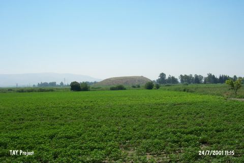 |
|
Type:
|
Mound |
|
Altitude:
|
125 m |
|
Region:
|
Mediterranean |
|
Province:
|
Hatay |
|
District:
|
Kirikhan |
|
Village:
|
Çamsari |
|
Investigation Method:
|
Survey |
|
Period:
|
EBA II |
|
|
|
 |
|
| It lies about 1 km off the eastern bank of the Karasu River; south of Çamsari Village; 10.5 km northeast of Kirkhan District of Hatay Province. It is also known as Halil Aga Höyük or Halil Bey Höyük. Materials collected from the surface in 1935 were analyzed by R. Braidwood. It was reported that the site had been occupied during the EBA; the Hellenistic and Roman Periods. It was re-investigated in 1998. The floor was measured 225x145 m while it decreased to 140x180 m on the top hill. Its 23 m height makes it one of the highest mounds of the plain. Sherds dating from the Phases G-H and I of the Amuq Plain were recovered. It takes place in the registered archaeological sites list prepared by Ministry of Culture and Tourism. |
| Location: |
| Geography and Environment: |
| History: |
| Research and Excavation: |
| Stratigraphy: |
| Small Finds: |
| Remains: |
| Interpretation and Dating: |