|
©The Archaeological Settlements of Turkey - TAY Project
|
|
|
|
|
 |
Uluabat Köprüsü |
|
|
|
|
For site maps and drawings please click on the picture...  |
For photographs please click on the photo... 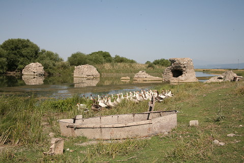 |
|
|
|
|
Type:
|
Bridge |
|
Plan Type:
|
|
|
Year of Costruction:
|
|
|
Phase:
|
Early |
|
Investigation Method:
|
|
|
Altitude:
|
10 |
|
|
|
|
Region:
|
Marmara |
|
Province:
|
Bursa |
|
District:
|
Karacabey |
|
Village:
|
Uluabat |
|
Antique Name:
|
|
|
|
|
  |
|
| F.W. Hasluck saw and briefly introduced the bridge over Kocasu (Rindakos) in the Mustafakemalpasa District of Bursa in the early 20th century [Hasluck 1910:78]. J. Lefort refers to the bridge in his study on the roads of Bithynia [Lefort 2003:467]. The name of the bridge which is on the Byzantine road leading from Cyzicus to Dorylaion is also referred in some Byzantine resources [Lefort 2003:467, no. 45]. The bridge was built in north-south direction over the Uluabat Stream that flows in east-west direction. The bridge is believed to be related with the Lopadion (Ulubat) Fortress. But due to the housing development no connections remained after the last abutment in the south. Only the bridge abutments survived to date. Uluabat Stream provides the discharge of the Uluabat Lake. Since the stream is insufficient the bridge does not contain any cutwater type of elements. Alternating wall technique was applied on the structure [TAYEx 08.07.2008]. |
| Location: |
| Geography and Environment: |
| Research and Excavation: |
| Description: |
| Finds: |
| Interpretation: |
| Destruction: The environs went through a heavy destruction due to housing. Only the bridge piers remained [TAYEx 08.07.2008]. |

