|
|
||||
|
|
||||
|
Cemile Kuyusu 2 |
||||
|
For cave maps and drawings please click on the picture... |
For photographs please click on the photo... |
|||
|
 |
|||
|
Type: |
Cave | |||
|
Altitude: |
1968 m | |||
|
Depth: |
-38 m | |||
|
Length: |
301 m | |||
|
Region: |
Central Anatolia | |||
|
Province: |
Konya | |||
|
District: |
Bozkir | |||
|
Village: |
Kizilin Yaylasi | |||
|
|
||||
 |
||||
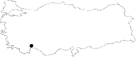
| It is located 200 m north of the cross road from the highway to Kizilin in Bozkir district; Konya province. The main entrance of Cemile Kuyusu is very large and provides access in three separate directions. A narrow and high gallery which follows the wall on the right side from the entrance; reconnects with the main gallery. The main gallery is covered with snow and ice; and has a descending declination. Following a short descent it gets narrower; then continues to the left and finally ends following a 15 m distance with an impassable gallery. The other gallery extends making zigzags and reaches a small room. The basin is filled with goat and sheep bones. The small room opens into a large hall. This gallery is enlightened by sun shine and ends at the entrance of the Cemile 2 cave. The cave consists of a complex system of fossilized waterways. It was initially found by the combined efforts of the BÜMAK Ğ SCVJ associations; it was measured and mapped by the same. |
| Location: |
| Structural Properties and formation : |
| Research History: |
| Findings: |