|
|
||||
|
|
||||
|
Incesu |
||||
|
For cave maps and drawings please click on the picture... |
For photographs please click on the photo... |
|||
|
 |
|||
|
Type: |
Horizontal Cave | |||
|
Altitude: |
1615 m | |||
|
Depth: |
-22 m | |||
|
Length: |
1356 m | |||
|
Region: |
Central Anatolia | |||
|
Province: |
Karaman | |||
|
District: |
Merkez | |||
|
Village: |
Taskale | |||
|
|
||||
 |
||||
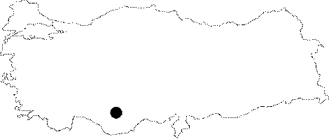
| Location: It is located on the eastern slope of the Incesu Creek to 9 m south; across the slope of the valley where the town of Taskale is situated; 45 km southeast of Karaman. |
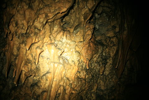
| Structural Properties and formation : Formed within the Miocene limestones; the cave system consists of two interconnected caves. Totally horizontal; they are adorned with rich decorations. Of the system where a small underground creek passes through in rainy seasons; the Incesu Cave is 1356 m long while the Asarini cave is 750 m long. The space between these two caves was closed due to collapses. It is a dry cave except the seasonal small lakes. The Incesu cave was formed within the Middle Miocene aged massive limestones which are highly pure and usually intact in horizontality Güldali et al. 1983:3]. The mouth of the Incesu Cave which faces Incesu Stream is very narrow. The cave extends after this narrow mound through a tunnel; 5-10 m wide; and 4-6 m high; by making zigzags; and curves; in line with the fracture systems as well. The declination of the cave is usuallly towards Yesildere; and not towards Incesu Stream as expected. This situation can be explained as follows: The cave had developed from the start as a subsurface stream flowing towards Yesildere; then it cut through the cave as the Incesu Stream enlarged vertically. It is found that Asarini Cave which is 300 m south of Incesu Cave; was part of Incesu Cave in the beginning; then it divided this cave system into pieces; as it sunk inside the bed of Incesu Stream. The cave basin mostly contains small size travertine ponds; and partially it is filled with rocks; and stone debris. There are stalactites; stalagmites; and columns inside the cave (Nadir et al 2005: 69-74). |
| Research History: It was researched by the Geological Studies Department of MTA General Directorate; and published in 2005. It takes place in the registered archaeological sites list prepared by Ministry of Culture and Tourism. |
| Findings: |